South Sister St. Marys, Tasmania
FORESTRY OPERATIONS AT SOUTH SISTER
D. E. Leaman
Each note refers to the same numbered point in the opinion and provides either additional information or discussion of the contributions of other consultants, sources, and parties.
References are cited as bracketed numbers as listed in the following bibliography.
1 - 4
Most reports prepared in connection with coupe NI 114A mention the issue of risk: and the term must be properly defined and appreciated to allow appraisal to be made of whether reasonable judgments have been taken, and appropriate actions recommended, in planning forest operations on the coupe.
Risk involves the existence of some hazard or action which might change conditions, a consideration of whether the hazard is likely to happen - or how likely it is to happen in a given period - and the nature and value of what is risked. If the value of what is risked is small then we may consider that it does not matter, however likely the chance of loss. If it is life, or some essential element such as water supply, then the value equation is changed radically.
This has been well summarised in (44, a classic work on the theory
of risk) by two statements.
'When we take a risk, we are betting on an outcome that will result
from a decision we have made, though we do not know for certain what
the outcome will be.'
'The essence of risk management lies in maximizing the areas
where we have some control over the outcome while minimizing the areas
where we have absolutely no control over the outcome and the linkage
between effect and cause is hidden from us.'
This completely defines the situation in terms of unseen, and underground, water.
The word 'risk' appears to have been first used in respect of physical conditions at South Sister in the 'Archaeology' evaluation of July 28, 2003 in the context of 'risk of collapse of coal mines under dolerite talus.' It is noted again on August 19, 2003 in respect of 'landslide risk' in a Soil and Water evaluation, and again in report (5) on October 20, 2003 by Forest Practices Board in the form 'as with most coupes on dolerite the (landslide) risks are few.' Report (5) notes further that the intake on Dublin Town Road (spring) should be protected by a 50 m exclusion zone in order to protect water quality. The report notes the presence of an old landslip area but makes limited special provision for it, other than a 50 m protection zone. There is no review of the implications from such an area, or consideration of protection of water volumes. No other intakes or usage is noted. Risks were rated as 'few' with the eastern end of the mountain protected from landslip risk by a forest reserve.
'Landslide potential' and 'potential landslide areas' are noted on a Forestry Tasmania planning map of May 15, 2003 (included here as Map 4) and the Soil and Water Evaluation of August 19, 2003 urged 'take care with culvert placements to avoid concentrating water in or above potential landslide areas'. However, as late as November 12, 2004 on a Peer Review Form of Plan PWJ0010 it was realised that this could not be determined: 'how are these potential landslide sites to be identified on site?' The certified Plan of January 5, 2005 simply states 'The Forestry Tasmania (Bass District) roading engineer will identify any sites (if any) that may be cause for concern.'
At no stage is the nature of any risk described in full and related to any potential loss - in any value terms, including water supply, off the coupe. Most comments by Forestry Tasmania or the Board apply to perceived hazards on the coupe.
In my first report (6) I emphasized the risks to stability and to
the many spring systems and considered that the eastern part
of the mountain should not be worked at all due to stability
problems. A monitoring and data collection program was recommended in
order to establish the likely nature of issues and the scale of any
risks.
This was a call for full assessment. It has never
happened.
The risks I identified in (6) were considered over-stated by the Board (7). These issues were discussed and rebutted (8).
Although assurances have been offered by the Board to the effect that there would be no significant risk to the stability of land or water supply around South Sister, no evidence has ever been supplied by it to support this contention - which is contrary to all general experience (as summarised in 1: pages 17, 30-31).
Standard industrial practice, in connection with any engineered or
other activity which might intervene in natural processes, involves
some prior investigation which is essential before any plans or firm
decisions can be prepared or taken.
This is a matter of care and responsibility since
ramifications are not always obvious and project costs and practices
may depend on the findings.
The need for such an exploratory approach has been demonstrated by
the changes described in (27) due to the first phases of
activity.
I have inspected some of the new developments and consider them
typical of the changes which occur once land is disturbed.
Domestic or town water supplies should be considered valuable and important at any time, even though it might be difficult to quantify their value. This is especially so when there are no obvious alternatives to the current mode of supply, should that supply be lost. If there is even the slightest risk that an action will lead to the loss or damage of such a vital supply, that action should be carefully considered and some provision should exist which accounts or compensates for possible loss.
Report (19) rightly notes that the fundamental problem is that no
one can be quite sure how much change will prove critical, or when its
application is critical.
This is why if the loss may be serious, we may choose not to act at
all. This is what should happen at South Sister in the absence of
comprehensive assessment and a serious attempt to understand the
circumstances.
5
Various experts, except those from Forestry Tasmania and Forest Practices Board who do not comment on the geomechanics of soils, agree that previously failed areas remain the key to future activity (see 1, 6, 8, 19, 20, 42 and Appendix 1).
6
The forest plan of May 15, 2003 has not been modified in respect of the groundwater regime and any relationships to the land stability of the coupe despite reports (6, 8) and this plan remains at the heart of the current proposal.
7
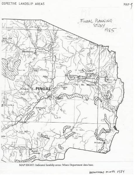
Various reports have agreed that the South Sister region has been subject to comprehensive slope instability of various types over a long period (1, 5, 6, 7, 8, 18, 19, 20, 25, Maps 4, 8, 10). Only FT (14) considered landslide risk as slight. FPB reports such as (5) and (7) note few failures. The Forest Practices Board thus understates the history and risks of the site and with little appreciation that failures can occur at very low slope angles - especially in previously failed material (also Appendix 1).
Reports (6) and (19) detail the conditions around South Sister to
show that (a) current low slopes of the coupe area are in fact largely
failed slopes and that (b) some very large failures have occurred
which involve the dolerite cap of the mountain and the coal measures
which underlie it. Both reports comment on the effect previous
failures have on the coherence and strength of materials and the
changed response to future trigger events.
Report (6) identified and listed the various types of failure which
have occurred in the past and could recur: small creeping zones,
larger rotational slides, deep failures, and column and block topple
collapses. The eastern side of the coupe was recommended for exclusion
since slopes were steeper and contained some large failure zones;
although only one is reported in (5). FPB maintain that the
preservation of a tree reserve on the northern edge of the coupe will
protect the steep slopes (5), but trees can fail along with the
material beneath if conditions upslope are changed.
Forestry Tasmania and Forest Practices Board suggest (23, 10-20/10/03) that since nothing has obviously failed in 'recent years' despite power line and communications work, then new activities will not be harmful. The same documents mention mining and failures were common during the mining period (e.g., 43). The difference between very limited long line activity with no significant disturbance, and an intensive forest operation over a sizeable area is a chalk and cheese comparison.
8
Study (1) suggests that most failures may occur in slope material due to poor cohesion on the underlying rock surfaces, especially if previous failures or movements have occurred (also 50). That study also showed that slides change the drainage patterns and the manner in which water and pressure build ups occur. This is a linkage to spring behaviour as well (42). Report (1) also indicates that most new failures are related to road excavations, drainage diversions, changes in cover vegetation, transport - all industrial activity, and may continue to occur for up to two years after clearing and working. Vibration is considered an important trigger factor (42, 52, 56).
Comments in (7) suggest that dolerite talus cannot and does not fail, especially at low angles. This ignores a range of physical properties and variations in this material. Indeed, the soils analysis offered by many FT and FPB publications (e.g., 46), is basic, simply descriptive and 'agricultural' and related to growing things: it is not geomechanical or geotechnical and does not adequately describe physical behaviour.
This is why (25) does not refer to such publications - they are largely irrelevant to the substantive matters of particle release, transport, deposition, erodibility, strength, cohesion, moulding or working, and effects on flow in ground. Appropriate professional advice must be sought and followed (as advised by FPB in 50).
9 - 10
FPB demonstrated a lack of understanding of groundwater systems with its comments on the nature of the hydrology of South Sister (compare 6, 7, 8). An indication of relationships is given in (34). Consultant (21) agreed that South Sister is a groundwater regime.
The significance of extreme events and the potential for them to
occur in the Nicholas Range-St Marys area was stressed by (25, 39,
55). The erratic nature of rain and flow events has also been noted in
groundwater and surface flow responses along the Break O'Day River
(see 35, 36, 37).
NONE of this has been accounted for in the forest plan nor included in
any form of risk assessment.
Annual mine records (54) for the Jubilee Mine comment on the fractured and faulted ground, and water flows - after rain. Much water infiltrated to the mine complex, and did so rapidly. The 1955 report showed that thick pockets of talus were saturated above the mine, so improving connectivity and rapidity of transfer. Consequently debates about the depth of the mine, or its relevance to the hydrology of South Sister, must consider that large volumes and high rates of transfer have been observed. This is typical of fracture systems, but not of consolidated porosity aquifers (see Figure 2 in which flow emphasis is related to faults).
11-12
I have reviewed the consultancy report of Dr Lane (21) regarding the effect of disturbance (the forest operation) upon infiltration and recharge. Important factors affecting effects and results which must be assessed include how much water is diverted from compacted areas, whether it is drained away and can infiltrate, and where. Dr Lane assumes that the water will be routed to uncompacted areas - but is this realistic, or possible in a broadscale clearing operation where water table conditions before the event have not been defined and drainage systems have therefore not been designed to match conditions? See (1 and 42) for discussion of this necessity.
MRT report (16) also notes that change can occur and advises careful control and management. Management requires prior knowledge and information. The FPB (51) has in the past also stressed the need for on-going maintenance to ensure that any protective measures continue to function.
Comments have been made by FT/FPB to the effect that no failures or hydrological effects have been reported from other coupes in dolerite terrain (15). I challenge this: I have seen some in southern Tasmania (at Taranna, Fortescue Bay and Catamaran, for example). Effects include marked changes in water flow, erosion and water quality.
The current coupe audit list of the FPB (33) does not provide for a
full tabulation of pre-existing conditions nor adequate comparison
with subsequent developments: the entire audit process is very limited
hydrologically (33).
It is necessary to systematically check and describe conditions at
coupes before and after logging. Unless this is meticulously carried
out, with procedures for reporting change, by qualified people using
objective criteria, then no one has any right to claim it does not
happen because they are 'unaware of it', or 'it has not been
reported'.
13
Report (21) claims that little research has been undertaken about
changes to groundwater supplies due to disturbance in forest, or of
effect on flow in fractures. This may be true of specific
forest-related research but it is not true in general. For example,
evaluation of water bore behaviour in Tasmania has shown that even
pumping patterns can alter flow behaviour due to disturbance of
particles or generation of new ones due to weathering (31).
Report (21) presents a narrow view of contamination since the
engineering practice known as grouting is intended to actually block
and then seal openings in the rock mass (pores and fractures). There
is a considerable literature (see 28) about this intentional
- relatively permanent - practice which, in principle, does not
differ from accidental - relatively impermanent - passage of
particles from surface erosion.
Report (21) comments that there is no literature on contamination of groundwater with sediment (contrast engineering literature such as 28) and yet the water can become turbid and the fine particles to be found near each spring suggests that the water can carry particulate matter.
The issue is how and why and this answer must lie in the properties of the local soils and the weathering products of the very fine grained dolerite which caps the mountain. These properties do not seem to have been examined by FT or FPB (15, 23) who simply state that the materials are not subject to sheet erosion, are 'least erodible', and not problematic. This is not the view of consultant (25), or of (21) who recommends protection of soils.
Actual measurements, undertaken by residents as a result of
recommendations in (6), show that there are variations in flow and
these are associated with changes in water quality (see Appendix
2). Report for DPIWE (21) notes this and even the FPB (15) admits that
poorly built roads can affect water systems.
Report (21) further relies on anecdotal comment that the spring flows
are regular and yet detailed reports (13, 14) show that some are
'seasonal'. See Appendix 2.
(53) shows that abnormal water movement - as occurs after storms
- transforms turbidity of surface water, and hence input to
groundwater, even when no particular surface disturbance is
involved. This is a natural process, but one which is amplified by
disturbance.
14
FT, FPB and consultant for DPIWE have each attempted an assessment
of the water consumption changes due to forest thinning and
regeneration at South Sister (13, 14, 21) which suggests a long term
water loss from the local system with a maximum value between 51 and
156 ML/year after a possible short period of increased run off. All
sources, including (9, 47), show that this run off period is unknown,
and unknowable, here and is variable in any case: each investigated
site has behaved differently (see examples in 9, 47). This variation
is supported by actual observations elsewhere in Tasmania (e.g. 29,
30). It is admitted by all that any calculations derived from the
literature are speculative estimates and should therefore be treated
as guides only.
The arguments of (9, 13, 21) are rendered imprecise by the complex
nature of the forest plan and its fire and regenerative components
coupled with mixed ground disturbance. There is no evidence that any
calculation offered provided for all such elements.
My own multi-catchment research (sample, e.g., 45), on water usage
changes due to land usage changes, indicates
(a) the initial greater yield period may be much shorter in Tasmania
than assumed by (13 or 21) and more like (29, 30).
(b) there is no surety that the flows of the run off period will
increase recharge, due to changes in surface properties, recharge may
be decreased for many rain events, and extreme erosive run off may
occur (30).
(c) the peak take up volumes during growth will be of the order
estimated by (21) but the term will be longer.
Note that all literature tends to quote annual values, but
(d) the seasonal variation factor is relevant.
Seasonal variations are important because they may impose a drought effect. This is often observed where annual behaviour is abnormal - and some vegetation dies since the water table drops below root depth: the rare event for mature, long-lived trees. Patches of forest die. This may also happen seasonally when particular seasons are extreme and it may also happen where non climate effects have lowered water tables. Any such effect may be amplified and occur repeatedly where reforestation growth imposes generally higher demands.
My research has not been introduced formally and completely here because the precise volumes remain subjective to some degree in the absence of specific work on the Nicholas Range.
In any event, none of the discussion about actual responses
and volumes due to reforestation or land use change is relevant to the
primary issue: namely what happens to the water table at times of
increased demand - however it is caused?
Everyone agrees that there will be an increased long term demand: that
must lower water tables and some springs will be lost or relocated. We
cannot know, or predict, the details.
It is clear, however, that FT should undertake such research
before risking water supplies or transforming
landscapes and it is interesting that references such as (13)
always select the published examples with the longest run off periods:
the non typical situation anywhere in so far as we know today. The
difficulty with selection of models with long early run off periods is
that these imply raised water tables, more erosion and more sheet run
off effects and hence more particulate matter in water supplies. Such
models are chosen because they allow more cancellation of the later
increased demand effect when the effect of many coupes is
combined. Such complex balances and calculations are not appropriate
in this case when the issue is very local water supply specific to the
South Sister area.
The Warra program has yet to offer useful results on any of these
matters (53).
Spring systems which have been stable and perennial in the long term, albeit with seasonal flow variations (as here) - and have not stopped even in times of great natural stress (Appendix 2) might well be converted to intermittent or ephemeral status (if not stopped completely) by changes in water usage by the forest.
15
FT and FPB undertook an inventory of water usage, as recommended by
(6). The results were reported by the FPB (12). It was determined that
local usage, from springs, was of the order of 120 ML/year, and that
some of this powered small generators. It was also noted that some
supplies were seasonal and leaky - a fact overlooked by (21). See
Appendix 2. It was claimed (12) that the small change in water usage
effected by regeneration would not make much difference to the
behaviour of springs.
No evidence in support of this view has ever been offered
Should FPB (12) then place the onus on residents to become more
water efficient in order to make up for any losses imposed
upon them due to the activities of another party? This is hardly a
duty of care and there is no mention of the possible effect of any
fall in water tables.
It is, however, an admission of risk by
the Forest Practices Board.
16
The unreliability of surface water supplies to St Marys led to an investigation of the use of groundwater (3). The crucial elements of this study were how to achieve the high flows necessary, and long term stability of yield (2). Since typical average yields from Permian and Triassic rocks such as occur south and west of the town are of the order of 1.5 and 0.5 L/s respectively, and those from alluvials are of similar order (38), the issue was how to achieve flow rates at least five times this (600 kL/d). Nothing else would suffice. Consultants argued that only intensely fractured rocks might provide this and so proposed a drilling program along the Cornwall and Gould Faults to the north of the town (2). There was little point drilling anywhere else: groundwater would be recovered - but not in sufficient quantities.
The supply requirement of about 170 ML/year for the town (3) was proven feasible after the drilling program was completed (4).
Note: 1 L/second = 86.4 kL/day = 31.54 ML/year
It is important that the yields achieved in the initial program be understood. Holes SM1 and SM2 were drilled upslope off Gardiners Creek Road beside the town. Hole SM1 was a fairly successful bore (180 kL/d; up to 3 L/s from Triassic rocks) but hole SM2 produced about a third of this yield. It was still exceptional in Tasmanian Triassic rock terms.
Less water was recovered from Permian rocks in these holes even though some Permian limestone was present in SM1. These results showed that the consultants were on the right track but had not struck the heart of the fracture zone - or perhaps something else. Basalt was not encountered in either hole.
Hole SM3, west of the town at the railway was much more successful; with about 3 L/s derived from each of the Triassic basalt, Triassic sedimentary rocks, and Permian rocks. These were quite anomalous values for each unit since even basalts average less than 2 L/s generally (38).
Bores at the railway station zone are along the fracture zone, do not derive any significant yield from cover or alluvials, and depend on the very local zone in which basalt is also present. Conditions at the supply bore at the station nearby are not known in detail (2) but are considered to be comparable.
Although SM3 made water from the thin Permian limestone as well there can be no suggestion that this is a major aquifer, or that any of the rock units are supplied catchment wide if the term catchment is taken to mean the upper Break O'Day system, since the units do not extend across it: they are either thin, or discontinuous, or do not occur east of the fault zone, or only possess their unusual properties near the fault zone. Further, holes SM2 and SM3 which were only partly anomalous are above regional catchment base and it cannot be argued that water in these is fed from the general catchment, as offered by FT (14): it can only be derived from the Gardiners Creek/Cornwall Fault zone area.
I conclude that the consultants were correct in their assumptions which had been based on early research work on fracture systems (28, 48, 49). This was astute judgment and it has not been appreciated by FT or FPB (13, 14), nor considered by MRT (16). In fact the FPB shows complete lack of understanding of this when it states (15) that (2, 4) provided no evidence of a preferential pathway to the town. No, the consultants did not: but their results, the bores, do.
The extent of anomalous flow in the region of the railway may be judged from driller's comments where the long term yield was considered to be 10 L/s and perhaps 20 L/s (4). This means that it was an impressive and unusual bore but I do not ascribe great reliance on short term driller estimates: the long term results are more important, and this hole has managed to perform well over several years although there is now some suggestion that, in extended dry periods, yields might wane a little from required values. These observations, if confirmed, might suggest that there are some problems in the fracture supply (the rocks are weathering and beginning to seal, or there is some disruption), in the fundamental storage (at head of Gardiners Creek on South Sister), or that recharge in recent years has been reduced (drought years?).
These issues should be investigated and should certainly be assessed before tampering with any possible part of the supply system. South Sister has to be included in this since the fracture system, arguably important to the town supply, feeds water from the mountain zone. We need to know just how much water is involved in this system and what effect changes might induce.
FT essentially agrees with this when it suggests (14) that fracture
flow is not estimable without much study. It is not possible to state
that a 156 ML/year change at South Sister will be undetectable at the
town bore (13): no one knows.
FPB, however, explicitly excluded consideration of fracture systems in
their commentary (13) when such systems were actually and specifically
targetted by the original consultants designing the water scheme (2,
3, 4). This is inexplicable.
The argument, presented by FPB and FT (13, 14, 23), that the Gardiners Creek area is only a small part (13, Maps 1, 6) of the regional catchment for the town water bore is quite invalid. There is no dispute that some of the water is derived more regionally, most of it, however, has to be much more local. FT and FPB have drawn heavily on the comments by MRT (16) - but not the remark that the judgment is based on a hypothesis about the catchment: namely that South Sister is only a minor part of the recharge area (see 23)
It is useful to note the entire passage from the MRT letter (16) because it has been selectively used.
The full statement in (16) reads
'..available quantity of the groundwater for the town water supply is regarded as having low risk of being affected by the proposed forestry activity in the vicinity of South Sister. This conclusion is also based on the HYPOTHESIS that South Sister is only a minor part of the greater catchments recharge area for Middle Triassic and upper Permian aquifers that provide water for the town water supply'.(sic)
FT and FPB have thus depended on a circular argument and MRT has not noticed the bore log showing the role of basalt to the yield of the crucial town bore.
Letter (16) really states that so little is known, including the details of the fracture zone, that recharge areas may be regional and that assumptions are hypotheses. It encourages monitoring studies. MRT (16) did not consider what was actually known about these unusual bores and no one else has reviewed the abnormalities which must be explained. Only (17) offers such an explanation (expanded here).
The chemistry of the town bore water (2, 3) with its high iron and manganese levels may reflect passage through, or storage in, rocks such as dolerite or basalt. Manganese, in particular, is suggestive of such associations.
The conclusion drawn by (21) that the town supply is likely to be unaffected by activity on South Sister is an opinion only, and one which excluded any consideration of the supply hypothesis involving the local geology and fracture system.
18
Prior to engagement of a hydrologist, Forestry Tasmania deferred completely to the Forest Practices Board officers regarding hydrological and stability issues. Refer to (5, 10). That hydrologist admitted lack of experience with groundwater issues (10) but this did not mean that the resulting report (14) was discounted (see 15).
Correspondence (11) shows that M. Latinovic of MRT was consulted for some advice and FT were told firstly to consult an experienced groundwater expert for a general desk review, and secondly to undertake an evaluation of flow regimes in the area. FT was prepared to countenance the first of these - an approach which could provide ideas but no ultimate demonstrations - but not the second on the basis that the results would only be locally useful (11). This, of course, is the entire point: this is a local problem.
FT concluded (14) that the entire situation was simply speculative - an admission that actions were to be taken in the absence of any real information or guidance.
In other words risks could be taken in total ignorance. This made no difference to the approval process. FT was happy with its own investigations, or those of FPB, and would not seek independent advice. Rather, it would proceed with 'some sort of estimates of changes in forest water' in the absence of any local data; and the implications involving groundwater were ignored or overlooked.
This same attitude is evident in (26) where it is claimed that any resolution depended on the Board's experts only. Document (26) mentions water quality occasionally but offers nothing about water quantity.
The forest plan (24 item 6) requires care, and expert on-the-spot advice, in culvert placement and water direction. This is essential when the water involved is groundwater and people are dependent on that water.
Reference (57) provides a number of case histories in which
ignorance of groundwater and its relationships leads to legal,
administrative, scientific and practical problems. Some of the
problems involve loss of spring systems. Our current law lacks this
insight (30, 58).
Even so, the State of Environment Report (40), notes that the
relationships between land usage and groundwater conditions are not
defined; that there is 'limited information on quality and quantity
and hydrogeological properties associated', and 'considerable
uncertainty in statewide assessments'. MRT (16) shows that these
comments apply in the specific case of St Marys and South Sister.
19
FPB report (23 and many others) imply that many risk scenarios are unscientific and alarmist. Yet there have to be risk analyses: grounded in scenarios involving groundwater or stability factors based on the best data available. Forestry Tasmania has not presented such an analysis.
Instead, there are claims that objections have been shown to be unscientific are improper and lack independence (see especially 10 - McIntosh to Corbould, 21/12/04). Given the admissions (in 26, see comments above) this is wholly unjustified.
The State Policy on Water Quality Management (endorsed by FT, see 41) requires application of the precautionary principle to achieve objectives. The Tasmanian Parks and Wildlife Service also uses the principle of precautionary management.
20
The original evaluation (FPB) and plans (FT) for coupe NI 114A (Map 4) were cursory - as if this was an isolated, typical, normal coupe - and did not recognise the significance of local water supplies and the dependence of local residents upon them and consequently no provision to protect them generally. Only one protection was applied (5) - see below. The possible risks to the town supply were not even contemplated, let alone evaluated - and these organisations have still to do this (see 15, 20, 23).
It is not good enough to claim that the Forest Practices Code does not require exhaustive assessments of every coupe (26). It may not but, where there are legitimate concerns and risks then surely particular coupes should be chosen for assessment. Coupe NI 114A would seem to be in this category.
My first report for residents (6) drew attention to some deficiencies in the Forest Practices Code (33), since supported by DPIWE consultant (21), and the discretionary powers under section D2.2. These have been discounted on the basis that there is no, or low, risk to water supplies. This is hardly the spirit of the Code. In my opinion there is a very real risk to water supplies around South Sister.
The large number of hydrological and hydraulic variables involved in the groundwater process necessitates the provision of a reliable data base supported by long term observations. Flawed planning assumptions can result in serious damage to groundwater systems.
Code rulings have also been applied inconsistently. Thus, in the case of springs, which should have protective exclusions about them only one communal spring zone is to be modestly protected (with a limited 50 m zone). The protective zone quite ignores the radius of influence or collection of water.
Further, as pointed out by (22), other forest zones in which domestic spring supplies are present, have been protected with exclusion zones up to 300 m wide. Why and how is South Sister so different? FPB comments on this (23) do not answer the question since water supplies are at risk and there has been no demonstration that they can or will be protected. Local details such as slopes are not the issues: protection and risk are.
The certified forest plan (prepared and certified by the same
person) assumes that no part of the coupe is within the town catchment
for St Marys, something which even the FPB disputes (13, 14, 16, 23),
and quite ignores the issue of local springs (under its Item 6).
This is simply unacceptable.
SECTION ONE: REPORTS AND CORRESPONDENCE RELEVANT TO SOUTH SISTER - MATERIAL UPON WHICH THE OPINION RELIES
1. Forestry Commission. Alloy Perera project officer. Landslip susceptibility in Tasmanian forests. Nov. 1992.
2. Sloane Weldon P/L, Groundwater Prospects: St Marys township. Report 1997/87, Jan 6, 1998.
3. Sinclair Knight Merz/Break O'Day Council. St Marys water supply strategy. June 1998.
4. Sloane Weldon P/L, Groundwater drilling, supplementary water supply, St Marys. Report 1998/84, Nov 10, 1998.
5. Forest Practices Board. McIntosh, P.D. Report on visit to coupe on October 14, 2003.
6. Leaman Geophysics, Appraisal of initial forest plan. South Sister-Nicholas Range. Hydrological and landscape observations. Nov 23, 2003.
7. Forest Practices Board, McIntosh, P.D. Comments on Leaman, Nov 23, 2003; Nov 28.
8. Leaman Geophysics, Comments on FPB criticisms of Nov 28, December 4, 2003.
9. Forestry Tasmania. Lunchtime lecture 'Understanding the water demands of forests', S Roberts. website.
10. Forestry Tasmania FOI request correspondence as supplied. emails between S Roberts and P Rosevear, Nov 4, 2004
11. Forestry Tasmania email, S Roberts to P Rosevear, Nov 11, 2004.
12. Forest Practices Board, McIntosh, P.D., letter, Effects of harvest on domestic water supplies, Dec 9, 2004
13. Forest Practices Board, McIntosh, P.D. Brief review of evidence relating to effect of coupe NI 114A on water yield of St Marys township and domestic water intakes. Dec 20, 2004.
14. Forestry Tasmania. S Roberts. South Sister and harvesting in NI 114A. Dec. 2004.
15. Forest Practices Board, G Wilkinson, letter, Dec 22, 2004.
16. Mineral Resources Tasmania, M. Latinovic, letter. Jan 7, 2005.
17. Leaman Geophysics, opinion - hydrological conditions and risks South Sister and St Marys water supply. Jan 23, 2005.
18. David Stapledon, letter, Jan 30, 2005.
19. Ralph Rallings, Coupe NI 114A, landslide risk assessment. Feb, 2005.
20. Leonie van der Maesen, letter, Jan 31, 2005.
21. Patrick Lane, consultancy report for Tas DPIWE. Scientific review of water supply impacts of proposed forestry operations in state forest coupe NI 114A at the South Sister, north of St Marys. Feb 4, 2005.
22. Leaman Geophysics, Leaman, D.E., Letter, comparison of Koonya and South Sister, Feb 7, 2005.
23. Forest Practices Board, letter, G. Wilkinson to D. Clement, Feb 25, 2005. including McIntosh report dated Feb 10, 2005.
24. Forestry Tasmania. Forest Practices Plan as certified 5 Jan 2005.
25. Owen Ingles. Notes of a visit to a proposed logging coupe (NI 114A) at South Sister, NE Tasmania. Mar. 3, 2005.
26. Forestry Tasmania. Letter, P Johnstone to F Daily, Request under S29. Feb. 24, 2005.
27. Statutory declarations from residents and observers around
South Sister.
e.g. Frances Daily, Ashley Mason, Percy Wright, David Clement
SECTION TWO: BOOKS AND GENERAL REFERENCES IN PUBLIC DOMAIN
28. Natural Research Council, USA. Rock fractures and fluid flow.1996. National Academic Press, Washington. (esp. ch.7 - Induced changes to fracture systems, p. 405-454).
29. CSIRO Land and Water. Reports 1/02 and 2/02, analysis of water quality and yield to forest harvesting doleritic soils, Musselbro Creek, and comparative catchments on granitic soils in NE Tasmania. 2002 (several authors)
30. Leaman Geophysics, Leaman, D.E. Land use and maintenance of base flow. Proc. conf. TCT/EDO, Hobart, 2003. EDO website publication.
31. Mines Department Tasmania. Leaman, D.E., Considerations on a water bore at Peckham Vale, Tasmania. Tech Rept. 15, 1972
32. Forest Practices Board, McIntosh, P.D. Guidelines for forestry operations on soils formed in dolerite slope deposits (dolerite talus). Jan 4, 2002.
33. Forest Practices Code, 2000 and audit checklist 2003-4. Forest Practices Board.
34. David Leaman, 2004. Set of educational leaflets on water use, definitions and the water cycle. Available as file LEAFLETS.PDF
35. Mineral Resources Tasmania, 2004. An overview of the Mineral Resources Tasmania statewide groundwater monitoring network, A. Ezzy. Record, 2004/04.
36. Leaman Geophysics, 2004. Appraisal report. Mineral Resources Tasmania groundwater monitoring network. Present or potential value and future requirements or actions. Report for MRT, August.
37. Mineral Resources Tasmania, 2005. MRT statewide groundwater monitoring network: data collection - September 2004. Record 2005/01.
38. Mineral Resources Tasmania, 2000. Groundwater resources of the northern midlands and Fingal Valley regions, Kris Taylor. Record 2000/04.
39. Bureau of Meteorology, 2005. Notable point rainfall events. Refer Cullenswood. Also daily data for Dublin Town, German Town, St Marys, Gray.
40. RPDC. State of environment report, Tasmania, 2003. Chapters on water. 'Inland water and wetlands'.
41. Forestry Tasmania, 2004. Elliott & Hodgson. Water sampling by Forestry Tasmania to determine presence of pesticides and fertiliser nutrients 1993-2003. Tasforests, 15, 29-42.
42. Mines Department Tasmania, 1988. A.L. Telfer. Landslides and land use planning, Geological Survey Bulletin, 63.
43. Mines Department Tasmania. 1991. C.A. Bacon. The Coal Resources of Tasmania. Geological Survey Bulletin, 64.
44. Peter Bernstein,1996. Against the Gods: the remarkable story of risk. Wiley.
45. Leaman Geophysics, 2004. Expert evidence: Concerning Swanport River Catchment and effect of dam at Stonehenge. Including addendum. PDF files.
46. Forestry Tasmania, 1995. Grant et al. Forest Soils of
Tasmania.
Forest Practices Board, 2002. P McIntosh. Guidelines for forestry
operations on soils formed in dolerite slope deposits (dolerite
talus).
47. Vertessy, R.A., 1999. The impacts of forestry on stream flow - a review. In J.Croke & P. Lane (eds). Forest management for water quality and quantity. Proc. 2nd Forest Erosion Workshop, May. Report 99/6 CRC for Catchment Hydrology.
48. David Leaman. Water Supply in Crystalline Rocks. Thesis, University of Tasmania, 1965.
49. David Leaman. Ground water prospecting and use of integrated geophysical approach. Proceedings of International symposium on development of groundwater resources, Madras, India, 1973.
50. Forest Practices Board, K. Kiernan, Forest Practices News 3 (4), p. 16. (caution where there is a known legacy of slope instability)
51. Forest Practices Board, N. Duhig, 1998. Forest Practices News, p. 8. Forest landslides.
52. Forest Practices Board, K. Kiernan, 1999. Forest Practices News, p 18-20. Did the Earth move for you?
53. Forestry Tasmania et al. 2001. Ringrose et al. Hydrology of small catchments in the Warra LTER site: objectives and preliminary analysis. Tasforests 13 (1), 31-44.
54. Mines Department Tasmania. Director of Mines Reports 1943-1960 for Jubilee Mine.
55. Robert Mesibov, 2001. The Rain at St Marys. Tas. Naturalist, 123, 5-11.
56. Geoscience Australia, 2004. What causes landslides?
57. Robert Glennon, 2002. Water Follies: groundwater pumping and the fate of America's fresh waters. Island Press.
58. Leaman Geophysics, 2004. Issues of water use and management in Tasmania. Paper for conference 'Protecting our liquid assets', August. Environmental Defenders Office website. PDF file.
APPENDIX ONE: NOTES ON DOLERITE TALUS SLIDES AND SLOPES
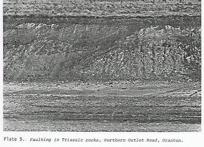
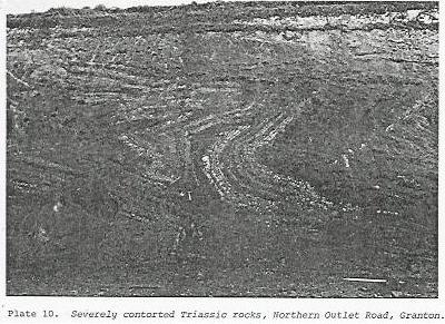
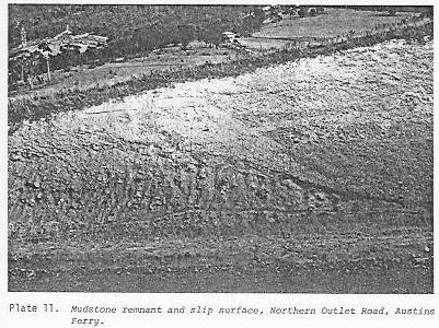
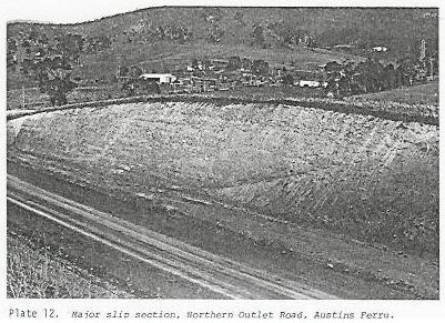
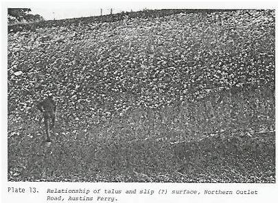
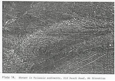
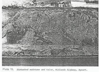
It was not appreciated until large road cuttings were developed in Tasmania during the 1970s just how common and significant failures in dolerite talus had been, or were. Many slopes have been draped with debris during ice age and post ice age time and substantial movements have clearly occurred. In many cases the movements have involved considerable areas (up to hundreds of metres by tens to hundreds of metres) but relatively thin parts of the cover (a few metres to perhaps very few tens of metres).
Many of these failures have presumably occurred at times of climate transition or extreme events and this is indicated by the variations in oxides present in different deposits, many of which are stacked upon each other (as at Austins Ferry and Otago). The presence of much silica and carbonates in many deposits reflects the passage of much water, or the concentration of flow at basal surfaces. The carbonates are often layered at slip surfaces (Leaman, 2002). Many failures have incorporated upper Triassic mudstones and coal measures (at Austins Ferry, Otago and Dysart). The Triassic rocks tend to be folded and faulted but the effect does not extend to great depths. This shows that not all failures occur at the contact between debris and bedrock but may involve movement along unit boundaries within the bedrock. Many failures have occurred within, or above, material which has previously failed. Many failure surfaces are extended low angle surfaces but some are classic slip circles.
Documentary evidence of these characteristics is available in some documents produced by Mines Department Tasmania during the road-building period (e.g., Leaman, 1977). Photographs from this reference have been reproduced here.
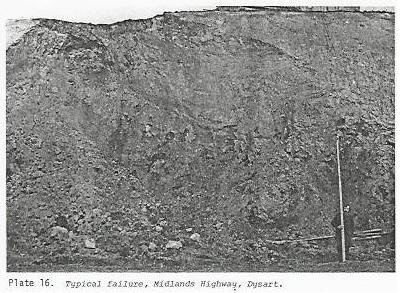
The sites at Otago, Austins Ferry and Dysart have been subject to further study (Davidson, 1999; Heath, 1997; W.R. Moore, pers. comm.). Although the climatic conditions are now much drier than when many of the deposits were formed or moved frequently the material is still unstable (Otago) or subject to failure (Austins Ferry) with addition of water. Present slopes at each of these sites range from negligible to perhaps 20 degrees and encompass the range evident at South Sister. Slopes along the east side of South Sister, with the few large failures still evident and with minor evidence of on-going creep and seepage, are typical of all sites while the slopes of the south face of South Sister are in fact steeper than much of the Hilton Road part of the Austins Ferry zone. All show humpiness and suggest subtle rotations or significant creep at some time. Flows and creep of material may run considerable distances, as has happened near Baskerville (Brighton) and across Glenorchy (from Mt Arthur in 1872). Vibration from traffic, coupled with compaction, has led to on-going minor failure of the Midland Highway at Dysart and repeated re-packing of the road surface in order to minimise further vehicular effects related to compaction and vibration.
These observations offered a salutory lesson when first observed and should still do so today. It is a pity that weathering and vegetation of cuttings has obscured the information. Good drainage is critical in every case and the present drying climate is a helpful factor.
Davidson, M., 1999. Land stability and hydrological characteristics of the Otago region. Thesis. University of Tasmania.
Heath, R.G., 1997. Geotechnical risk assessment of the Claremont area. Thesis. University of Tasmania
Leaman, D.E., 1977. Brighton. Explanatory Notes. Geological Survey Explanatory Report, Mines Department Tas.
Leaman, D.E., 2002. The Rock which makes Tasmania. Leaman Geophysics.
Plate 9
Plate 10
Plate 11
Plate 12
Plate 13
Plate 14
Plate 15
Plate 16
APPENDIX TWO: OBSERVATIONS ON WATER SOURCES
I recommended in my first report (6 - Nov. 2003) that observations be made of flow and changes in water quality at springs around South Sister. These are necessary in order to assess the nature of demands upon the spring system and the nature of its responses to natural events, including rainfall.
Some data may be reported. All have been collected by residents, not the proponent of land use change - Forestry Tasmania.
About 3.17 ML was drawn from the communal spring on Dublin Town
Road between December 14, 2003 and April 5, 2005. This is a demand
averaging 6600 L/day.
The spring has no difficulty meeting this demand at present and runs
to excess in the long term. There are, however, seasonal variations in
rate of supply and the winter rate is about double that of the summer
rate. For the tested year winter is effectively May to August.
Permanence of supply is ascribed to the shaded nature of the
catchment, the substantial catchment upslope on South Sister, and the
lack of disturbance or other processes which might lower the water
table abnormally.
Observations of spring systems near Seaview Farm at German Town,
which are supplied from the lower part of the coal measures and basalt
show a much greater variation.
There are strong, direct responses to rainfall which rapidly decay but
the pattern for 2004 shows that there was a strong recharge event in
late January and the system slowly emptied until late August and flow
ceased in September, before further rainfalls partly charged the
system in October. Low flows have persisted until March 2005.
It is not yet known if 2004 was a typical year, given the very heavy
summer rainfall and recharge, but the summer 2005 pattern may be
typical. It is possible that typical daily winter flows are of the
order of 1500 L and typical summer flows are of the order of 300
L. This spring system stopped flowing three times during the recorded
period which reflects depression of water table, lack of recharge and
limited storage away from the bulk of South Sister. The ground storage
for the Seaview Farm springs is not South Sister but the shelf of land
extending north from the saddle at the east end of South Sister. This
is a much more limited and exposed system and information from it
serves only to suggest seasonal and climatic effects, and storage
responses.
The main spring system at Dublin Town Road may have weathered 2004 better than in a normal year due to the exceptional summer recharge. Responses for 2005 will suggest normal patterns given the absence of intense summer rains and reduced recharge. Drought years, or other sources of water loss (such as forest growth), may well alter the flow patterns.
This very basic data is the least required, over a few years, for an understanding of the local hydrology.
RECORD OF SITE VISITATIONS
Prior to 1973 my visits to the region were largely restricted to
the plain and lower slopes of the Break O'Day River and tributaries
for groundwater assessments. I did visit South Sister-German Town on
some occasions.
During the period 1973 and 1981 many visits were made to the St Marys
area, including the Nicholas Range and Fingal Tier, as part of a coal
and structural assessment program. I am, therefore, familiar with the
geological construction of the range and the materials on it and the
means to evaluate them. My work forms part of the geological knowledge
data base of the area.
It is no longer possible to identify precise dates of visitation for
this early period.
The conditions surrounding the St Marys town bore were reviewed (as
part of a different problem) on September 4, 2003 and the conditions
around South Sister and German Town were examined on November 18 and
19, 2003, reviewed on February 7, 2004 and again on April 3 and 4,
2004.
Further inspection occurred on May 14, 2004 and December 12, 2004.
A final inspection of current conditions was made on April 12 and 13, 2005.
I affirm that I have made all enquiries which I believe are desirable and appropriate and declare that no matters of significance which I regard as relevant have, to my knowledge, been withheld from the Tribunal.
I am, however, of the view that much needs to be done to fully resolve this difficult and contentious problem but that the effort necessary will take time, expense and expertise beyond the resources of the residents of the area.
Dr. D. E. Leaman
May 8, 2005
CURRICULUM VITAE
CONSULTANT GEOLOGIST/GEOPHYSICIST/GEOHYDROLOGIST.
Qualifications:
Professional memberships include:
Listed on register of Australian engineering geologists.
Outline of experience in GEOHYDROLOGY and ENGINEERING GEOLOGY. (a subset of complete CV)
1998 -: Catchment research involving role of base flow and hydraulic properties of catchment media for assessment of land use change and implications for water yield.
1981 -: Consultant, Leaman Geophysics, operating Australia-wide.
OTHER CONTRACTED ACTIVITIES: Teaching, University of Tasmania.
Teaching, TAFE, U3A
1995-: Adult education classes, geology, philosophy, water issues, risk.
PREVIOUS EMPLOYMENT
CURRENT RESEARCH PROJECTS
On-going research: now privately funded (since 1998) by Leaman
Geophysics.
Publication record:
Includes 60 fully refereed scientific papers in national and
international journals,
21 books and maps for Geological Survey Tasmania,
3 other books in the public domain,
3 course note texts: on dolerite, water, applied geophysics (CODES)
series of excursion guide books (UTas)
89 published geological reports,
55 unpublished government reports on open file, 5 published extended
abstracts,
10 short abstracts,
6 refereed long abstracts,
~255 open file public domain industry reports,
6 Tas government industry reports,
10 industry-university cooperative study reports.
Publications cover range of professional experience including
hydrology, engineering, structural geology and applied geophysics.
Samples of relevant publications and report studies are:
STATEMENT: AREAS OF EXPERTISE
My principal hydrological focus has been with respect to groundwater and its interactions with surface water - including evaluation of rock media properties in the storage of a catchment. This requires integration of the effects of climate, seasonal effects and the implications of land use changes, such as forestry and clearing.
Groundwater is the crucial element which supports water supplies and stream flows and, whether as soil moisture or true groundwater, it sustains long term vegetation patterns. This leads to an integrated holistic view of water use and of catchments as a whole. The issue of water quality, and possible contamination, is directly linked to such studies.
Original hydrology contributions have been directed toward review of fracture flow and the hydraulic theory necessary to undertake complete water budget studies in catchments at all scales; hence the 1971, 1973, 1976, 1994, 1999 items in particular. These items combined with new research studies (2004 reports) have enabled development of software to model the hydrological implications of land use changes. The program is now known as CRAFTY (catchment, research, assessment, flow, transmission and yield): so named because it deals with all parts of the water cycle, and not the usual restrictive engineering approach of surface water dynamics only.
Due to work duty requirements (after 1973) and project character (after 1981) a substantial component of my contributions have taken the form of whole catchment and basin analysis and the geophysical methods necessary to achieve such assessments. Few such items have been listed.
Related geotechnical and soils experience overlaps the hydrological
content.
In particular, and of relevance to the evidence presented here,
experience of land stability problems extends the length of my career
(from first task in 1966 to consultant to MRT on observations,
methodology and presentation of data in 2004-5). My especial
contribution relates to identification of previously failed ground and
assessment of risk of further failure using various methods, including
geophysics. This is important in those situations where slopes have
been modified by previous failure and are low enough to suggest
stability. My long involvement with dolerite and its products
emphasizes relevance to comment in the South Sister case. Much of the
existing geotechnical material property data base referred to by many
other authors was generated by me between 1966 and 1981, and
supplemented since 1995. This is especially true of dolerite-derived
materials.
Post 1998 hydrological research projects (privately funded) have added
to some elements of this data base and provided perspective on issues
such as forest water use and land use change: topics not researched by
any Tasmanian agency.
May 8, 2005
9657 (2, 5, 10, 58)