South Sister St. Marys, Tasmania
[Notes of a visit to a proposed coupe (N1114A) at South Sister, NE. Tasmania; supplementary page]
An inspection of this proposed coupe (NI114A) was effected on 11 February 2005, following an examination of preceding documentation which included Forest Practices Plan PWJ0010 and records including mining, rainfall, soils, geology and specific reports or papers by Mesibov (2001), Stapledon (2004,2005), Crowden (2003,2004), Roberts (2004), Rallings (undated), McIntosh (2003), van der Maesen (2005), and other reference material such as the Forest Practices Code (2000), and St Marys geological sheet (1984), St. Marys and Dublin Town topographical maps 5839 & 5840 (1986), Land Systems of Tasmania Region 4 (Pinkard, 1980), publications of my own and numerous other sources. On various specific issues arising in my own fields of expertise (soils, landslip, geomorphology, roads, risk management) I find as follows.
A least considered but dominant feature of this coupe zone is not just the total rainfall, but its intensity. One tends to think of the West Coast as wet, but as the standard design guide for Australian Rainfall and Runoff (Institution of Engineers, 1987) shows, the small zone around the South Sister has by far the most serious rainfall intensity in the whole state. The 1-hour, 2-year, average recurrence intensity is some 45mm/hour and the 72-hour 50-year recurrence intensity exceeds 4.5mm/hour. It is the combination of intensity and duration which leads to major landslips of disastrous proportion as Lumb (1975) has clearly shown. Inspection of the rainfall records for St. Marys from 1894 to 2004 indicates disastrous conditions in 1911, 1929, 1956, 1969 and 1974 - always in March, April or May. In terms of risk management alone, it would be quite irresponsible to conduct any roading or harvesting operations during that period of the year. This should be brought to the attention of Forestry Tasmania as a matter of urgency, as lives could be at risk.
On the matter of landslides, I substantially agree with the observations of Rallings, whom I know to be a very competent and experienced engineer, and I endorse his conclusions. As engineers are aware, there are basically two kinds of land instability, in soil (including talus) or in rock. I note that the soils at this site (as distinct from talus) are very thin (generally less than 1 m depth), and cannot therefore give rise to other than very localised, minor slip movements. When slips occur they will be either in talus (which normally requires a high slope angle) or in rock due to joints, bedding or like discontinuities which are 'lubricated' by percolating water and/or clay particles. Such slips are usually of quite substantial size.
Rallings noted recent slips which he described as 'within 50 years'. This agrees well with my own observations at the site based on tree sizes and the expected average return period of around 20 years between major hazard rainfalls (one seems due now, if climate change has not occurred). According to Manson (Examiner, (9.2.2005), this coupe was previously logged in 'the 1970's and 1940's' presumably for sawlog only. This establishes two things: firstly, that sawlog extraction (only) does not disadvantage the water supply to St. Marys, and secondly, that the '1940's sawlog only extraction may have been associated with a slope failure recorded for 1950 during a period of comparatively dry conditions. (Mining and Rainfall records).
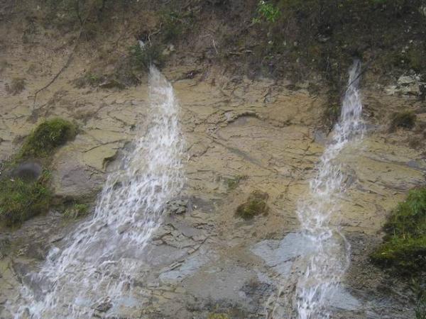
Since the average slope within the reduced area of proposed harvest is only around 8°, and the superficial soil is thin, I would not consider slips in soil or talus to be a hazard outside of the critical months referred to above. It is a different matter for deep (and hence potentially large) slips, where pore water pressure on planes of weakness in the rock strata can, and seemingly have, produced major slide events. Photo 1 shows springs with substantial flow from such an interface, even in a comparatively dry period.
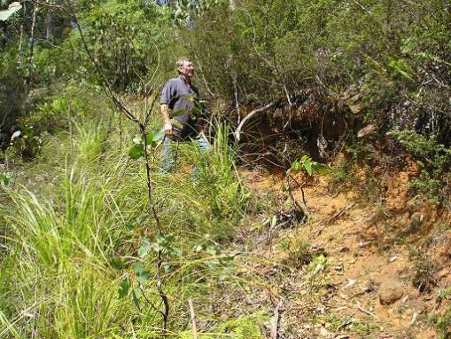
The local microclimate has another important effect on this proposed coupe. Basalt is present in quantity, and its fine grain structure together with substantial olivine and augite content lead to a much more rapid weathering than is usually found in dolerites, which are normally very slow weathering. Hand specimens selected randomly at this site all showed deep weathering. The consequence is twofold. Firstly, iron liberated from the olivine and augite - both of which are readily weathered - proceeds to flocculate the clays (dolerite in Tasmania is normally associated with montmorillonite type clays): and secondly, if intense weathering leaves only thin soil cover there must be appreciable erosion actively present. The latter is confirmed by Pinkard (1980) who describes the two types of soil within this coupe as being subject to 'moderate sheet erosion'. I wholly concur, from my own inspection. (Pinkard also lists them as <1 m depth. That depth was readily visible in a minor erosional/slip feature above the Dublin Town Road - see photo 2).
The overall soil description (omitting coal seam and mudstone zones) is of a sandy clay loam with gradational texture and moderate permeablility. In this, I wholly agree with Pinkard. And it must be noted that where slips have previously occurred, either shallow or deep seated, they invariably lead to decompaction within the slip zone, which poses an even higher risk for future slip activity, quite contrary to McIntosh's assertion that 'past failure or erosion is not necessarily an indicator of present risk' - the truth is, that it is an indicator of enhanced risk!!
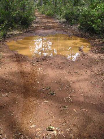
Due to the iron content, these soils appear red-brown; and due to the very fine clay content, they readily produce turbid water if disturbed. A typical photo of this occurring on the Derricks Marsh Road is shown (photo 3). By my own observation, that turbidity settles in a matter of hours, which indicates a flocculated particle size of around 2 - 3 microns. Thus it might confidently be expected that runoff from an unsealed road or ground from which understory has been cleared or otherwise disturbed will be taken into the porous rock strata in such a form that the fine micron-sized turbidity will be filtered out, causing both an irreversible blockage of the intake channels and at the same time lining discontinuities with a very low friction clay. It follows that safe slope angles prescribed in the Forest Practices Code probably need revision on a case by case basis, as the friction reduction can easily be as much as 50% (Ingles & Grant. 1975).
It follows from the above that, although I foresee no risk to the quality of the water supply at St. Marys, its quantity is likely to be irretrievably diminished by heavy traffic on unsealed roads and by removal or disturbance of the understory.
Lastly, it should be remembered that trees only stabilise shallowly, but water destabilises deeply - hence each site's water regime is CRITICAL, and in times of high rainfall, much needs to be shed, not absorbed or ponded. Who would dare to predict the intensity of rainfall in the aftermath of a logging operation? There is potential for disaster, and no risk analysis appears to have been made of this current proposal.
In summary, therefore, I believe there is no reason for concern over the winning of sawlog from this coupe (provided it is done with minimal ground disturbance), but that it would be quite irresponsible to extract or seriously damage the understory at this location, and therefore logging for pulpwood poses an unacceptable community hazard. A comprehensive risk management assessment by independent consultants is required in many other area of public concern, so it should also be undertaken here before any adverse consequences can result.
I am currently checking quantitative aspects of the samples which I took; but as that is likely to take some time I have thought it necessary to advise you of the broad outline of my findings promptly; especially calling attention to the danger period for any development works during March, April and May.
16 February 2005
Owen G. Ingles, B.A., M.Sc., Ph.D., F.R.S.C., F.I.E.Aust.,
M.I.E., M.A.I.E., C.Eng., C.Chem., C.P.Eng.
Owen Ingles P/L,
Soil Engineering and Risk Management Consultants,
Swan Point, Tasmania
FOOTNOTE: In the references that follow, particular merit attaches to those by Leaman, whose reputation in the fields of hydrology and geology of Tasmania is outstanding.
Anon. (1985) 'Municipality of Fingal Planning Study' Commissioner for Town & Country Planning, Tasmania
Clement, D.W. (2005) letter to Wilkinson, G. re FPP PWJ 0010 & Coupe NI 114A South Sister
Crowden, A. (2003,2004) 'Natural and cultural values estimation sheet, 6. Soil and Water', Forest Practices Plan for Coupe NI 114A
Forest Practices Code (2000). Forest Practices Board, Hobart
Ingles, O.G. & Grant, K. (1975) 'The effect of compaction on various properties of coarse-grained sediments' in Compaction of Coarse-grained sediments, vol.1 by Chilingarian & Wolf, Elsevier, Amsterdam, Netherlands, pp 293-348
Ingles, O.G. (2004) 'The Unrenewable Resource' J. Tas. Comm. Res. Auditors inc., vol.2 No.2, Supplement, pp 5-11
Institution of Engineers, Australia (1987) Australian Rainfall and Runoff
Keid, H.G.W. (1956) 'Report on Open Cut Coal at Jubilee Coal Mine'
Kiernan, K. (1990) 'Geomorphology Manuel' Forestry Commission, Tasmania
Leaman, D. (2002) The Rock which makes Tasmania Leaman Geophysics, Hobart
Leaman, D. (2003) 'Appraisal of Initial Forest Plan South Sister - Nicholas Range, Hydrological and Landscape Observations: Private Report and Answers to Critic P. McIntosh'.
Leaman, D. (2005) 'Opinions - Hydrological Conditions and Risks South Sister and St. Marys Water Supply' - Private report to D. Clement
Lumb, P. (1975) 'Slope Failures in Hong Kong' Jnl. Engng. Geol., vol.8, pp 31-65
Manson, S. (2005) as reported in 'The Examiner', Feb 9, p.8
McIntosh, P.D. (2003) 'Comments on Leaman Report of 2003'
McIntosh, P.D. (2004) 'Brief review of evidence relating to effect of Coupe NI 114A harvest on water yield of St. Marys township and domestic water intakes'. Forestry Tasmania internal report: also correspondence with Crowden
McIntosh Read, A. (1929) 'Supplementary Report on the Jubilee Coal Mines'
Mesibov, R. (2001) 'The Rain at St. Marys', The Tasmanian Naturalist, vol. 123, pp5-11
Pinkard, G.J. (1980) 'Land Systems of Tasmania, Region 4'. Dept. of Agriculture, Tas
Rallings, R.A. (undated) 'Coupe NI 114A, Landslide Risk Assessment'. Private Report
Roberts, S. (2004) 'South Sister and harvesting in NI 114A', Forestry Tasmania Internal Report
Stapledon, D. (2004,2005) 'Initial Forest Plan, South Sister, Nicholas Range. Comments on reports by D.E. Leaman and P.D. McIntosh'; also 'Assessing the Risk of Landsliding' - Private Reports
Tasmanian Dept. of Mines (1984) 'Geological Atlas, St. Marys' 1:50,000 series
Tasmap (1986) 'St. Marys 5839' abd 'Dublin Town 5840' 1:25,000
Van der Maesen, (2005) Open letter re factors of influence for the logging coupe NI 114A
Wilkenson, G. (2004,2005) letters to Clement and Whitton concerning Coupe NI 114A
Owen G. Ingles
B.A., M.Sc., PhD., F.R.S.C., F.R.P.S.L., F.I.E.Aust., M.I.E.,
M.A.I.E.N., C.Chem., C.Eng., C.P.Eng.
Myers Medal 1978
Wroclaw University Medal 1980
Medal of the Mexican Soil Mechanics Society 1982
Born Launceston, Tasmania, 22.12.1923. Graduated University of Tasmania and University of New South Wales.
Background:
Good working knowledge of French, German and Japanese, having
published and/or translated technical papers in all three languages.
Author/coauthor of over 150 books and papers in refereed journals
worldwide, from 1947 to 2002. Qualified chemist with special
expertise in clay chemistry. ASTM qualified Environmental Site
Assessor (USA, 1993). Until 2005, NATA inspector in Tasmania for
Materials Testing. Emeritus Member of the College of Civil Engineers
(12 December 2000).
Engineering Experience:
Research Officer → Senior Research Officer → Principal Research
Officer with CSIRO in Melbourne 1950-1973 inclusive; sometime Acting
Chief of the Division of Geomechanics. Principle responsibility
(research) for soil stabilisation, earth dams, pavements, mine
backfills, soil mechanics and soil variability (statistical control
thereof).
Joined the University of New South Wales in 1974 as Associate Professor of Civil Engineering Materials, with principal responsibility for teaching of construction quality control, pavement design and construction, geology and geomorphology, especially to post graduate students.
Retires into private practice in 1985, responding to complex engineering problems in Northern Tasmania, where he has designed new flood levees, silt storage ponds, rockfall defences and landslip countermeasures, as well as developing microzoned risk analyses (chiefly seismic) for insurers and Local Government authorities.
Associated Activities:
Was for 20 years a member of the steering and other committees of the
Australian Road Research Board; for some years East Asia
representative of the International Road Federation; past chairman of
the International Society for Applications of Statistics and
Probability in Soil and Structural Engineering; current Member of the
International Association of Bridge and Structural Engineers. A guest
lecturer on soil engineering in 15 countries of Europe, Asia and
America, and a visiting fellowship holder in the USA and Japan. Has a
special interest in the role of human error in civil engineering,
being the author of several in-depth studies thereof.
50419-6215 (1, 1, 5, 157)