South Sister St. Marys, Tasmania
- R.A Rallings, ME. FIE(Aust)., CPEng.
In the following an assessment is made of the risk of land-sliding that might arise from the proposed forestry operations on Coupe Nl114A.
The assessment is of a preliminary nature and has been based on the examination of geological maps and reports, topographical maps and air photos. The assessment has included an on-site inspection of the major topographical features both within the coupe and adjacent landscape. Brief visits were made to four relatively large and recent (within 50 years) landslides within the Nicholas Range complex.
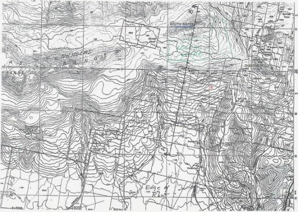
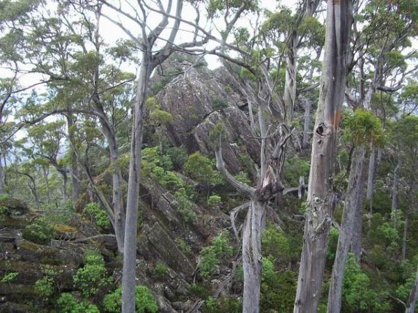
Figure 1 shows the relationship of the proposed coupe to the South Sister pinnacle and to the land below the coupe.
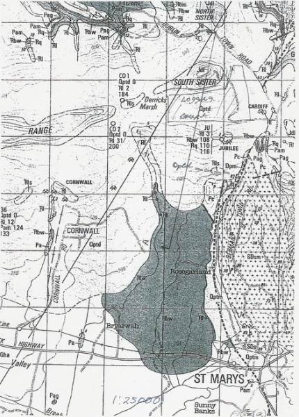
Figure 2 is an extract from the St Marys geological map.
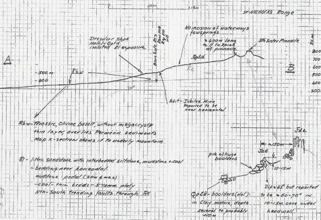
Figure 3 is a schematic, geological section through the coupe. The location of the section is shown in Figures 1 and 2. It attempts illustrates the likely relationship and principal properties of the major geological units that are relevant to slope stability. The salient features of these units are described below, in order of descending age.
There is a history of landslides within the immediate vicinity of South Sister. During the site visit, I was taken to the site of two major, quite recent slides by J McGiveron, a previous operations manager for the Huntsman Mine.
A slide was reputed to have occurred at Sea View Farm in about 1960. An inspection of an open paddock in moderately sloping land, just uphill of the Six and Twenty Falls, revealed a distinct landslide type feature of several hectares in extent. Back-tilting, a common feature of landslides was evident. This slide has occurred close to the Rl-Rbw contact.
A small slide (10s rather than 100s of metres in scale) was observed in Dublin Town Road. The slide was reputed to have occurred about 15 years ago. It closed the road for several days. The slide is within the Rl unit.
A possible landslide feature was observed within the coupe, near the NE boundary. It is probably the feature mentioned by P D McIntosh. The vegetation was too dense to gain an adequate view of the feature. The feature is within the Rl unit.
The conclusion from the above is that the Rl unit is relatively unstable. The spate of recent landslides is thought to be due to the reactivation of old slides.
P D McIntosh in one of his reports asserts:
'that almost all parent materials on slopes in Tasmania have formed in part by previous erosion under a different climate from that prevailing now and past "failure" or erosion is not necessarily an indicator of present risk'
While past failure 'might not necessarily be an indicator of present risk', it is certainly the most useful indicator of present potential risk of landslides. The above assertion fails to account for the very substantial reduction in shear strength that commonly arises in the initial failure.
The surface on which the sliding occurs will commonly become quite polished. The shear strength will drop to less than 50% of the initial shear strength. In consequence, the slide may be reactivated by small increases in moisture content or by ground disturbance.
I understand that you have received advice on the probability of reactivation of slides by David Stapledon. He is an internationally recognised authority in engineering geology.
The majority of the coupe is within an area of low ground slopes apart from the NE corner. The previously mentioned landslide type feature occurring here requires more detailed investigation.
Landslides within the southern arm of the coupe are thought to be unlikely. However this cannot be said for the steeper slopes below the coupe, those bounded by Struggle Creek and Gardiners Creek. These slopes are within the Rl unit. Any old slide within these slopes could possibly be reactivated by any increase in ground water levels.
As described previously, there is an outcrop of tilted dolerite about 150m south of the crest of Sousth Sister and about 50m below it. The cause of the tilting may be due to:
A large block slide movement, one that encompasses the slopes between Struggle Creek and Gardiners Creek.
I suspect the latter, though there might be further explanations in addition to the above. The reasons for my suspicion include the existence of a distinct valley between the two outcrops, the properties of the Rl unit, the N-S trending faults through the Rl unit. and the history of landslides. The above mentioned valley has not been filled in during the 140million years since the end of the Jurassic Period. Figure 3 illustrates the likely geometry of this hypothetical slide.
It has been recognised by various investigators that the proposed logging is likely to increase ground water content for a number of years. Such an increase in moisture content will increase the vulnerability of the slopes downhill of the coupe to landslides. At this stage it is not possible to express this increased vulnerability to sliding in terms of how much landsliding is likely to occur. It is possible that the increase is equivalent to a flea bite on an elephant and will not be significant. On the other hand it could be the straw that broke the camel’s back, with far reaching consequences. Further investigation is desirable.
The further investigations should include:
The purpose of the above is to develop a reliable geotechnical model of the site, one in which the potential effects of the proposed coupe on the surrounding landscape can be predicted.
While the Qptd unit, which blankets the coupe and adjacent slopes, is stable and strong, it has little influence on large-scale slope stability, except possibly in a negative way. It is likely to be highly permeable and will henceforth quickly transmit water to the lower and much weaker Rl unit. Large-scale instability will be determined by the properties and situation of the Rl unit.
This lower weaker Rl unit also underlies the much steeper slopes that surround the coupe. It has a significant history of land-sliding. The groundwater provides the vector by which the consequences of tree felling is shifted from the generally gentler slopes within the coupe to the steeper slopes outside of it. Based on the recent history of landslides, it is thought that the slopes adjacent to the coupe are already vulnerable to landslides. Any increase in ground water levels will increase this vulnerability
Neither the probability of landslides or the consequences of them can be determined from my limited investigation. A more detailed investigation, as outlined earlier, is required.
R.A Rallings, ME. FIE(Aust)., CPEng.
50419-7765 (1, 4, 18, 51)