South Sister St. Marys, Tasmania
FORESTRY OPERATIONS AT SOUTH SISTER
D. E. Leaman
FORESTRY-RELATED RISKS TO WATER SUPPLIES NEAR SOUTH SISTER AND ST MARYS
Forestry activities on Forestry Tasmania coupe NI 114A, including roadwork, thinning, burning, regeneration and drainage, on South Sister near St Marys have the potential to disturb the equilibrium of the currently stable landscape with various ramifications for water quality and quantity.
Groundwater, the out-of-sight but dominant aspect of the water cycle, and its relationships to slopes, materials, rock structures such as fractures, and soils controls what happens around South Sister, yet little attempt has been made to collect even the most basic information about the groundwater regime of the coupe area in order to plan forest operations. Nor has there been a proper evaluation of the risks to groundwater circulation associated with the proposed operations.
The slopes of coupe NI 114A are draped with dolerite-derived debris which has a clear history of failure. Many of the failures involve slippage at bedrock surfaces but the largest involve either the dolerite capping of the mountain, or the underlying coal measures. Changes in forest cover, extreme rain events, general disturbance or vibration, and unsatisfactory or altered drainage, may incite further failure. Further failure, or simple soil disturbance - including compaction or working (churning) - may lead to contamination of groundwater or groundwater flow systems which, in this region, are fracture-dominated and can be blocked or diverted.
There are no well-defined streams above an elevation of 600 m (the level of the coupe) and hence subsurface distribution of water is critical.
Residents around South Sister draw their water supplies from springs, or from small streams derived from those springs. Spring systems such as these are easily damaged - by disruption of outlet paths or of underground connections. Some springs and seepages are associated with old failure zones so that two-way changes might occur resulting either in loss of supply or increased instability, or both. There is no certainty that the spring system can survive vibration, trundling vehicles, tree felling, removal of understorey or burning.
The best protection is to avoid disturbance.
A demonstration of the sensitivity of these systems has already occurred since roading was installed. It was not predicted in the environmental evaluations for the forest plan that apparently permanent small marshes might drain and remain dry, or that new springs might appear, but this is typical of what can happen. Changed drainage along the roadways has also led to variations in infiltration sites and the ramifications of this have yet to be realised. Slope failure is possible. None of this was, or could be, planned in the absence of detailed investigations of the relevant physical characteristics of the site: namely stability and groundwater regimes.
Disturbances of the current equilibrium of the coupe landscape may have consequences beyond the boundaries of the coupe.
The town of St Marys derives its water supply from a bore system. It has been argued by Forestry Tasmania and Forest Practices Board that this bore system derives water from a very large catchment and that South Sister is not involved in any significant way. This argument ignores three important and unusual facts.
First, the rocks involved do not normally supply water at the rates
observed - and can only do so when much fractured and connected to
a large storage.
Second, bore test results show that the local, and rare, Triassic
basalt supplies a large proportion of the town supply. This probably
accounts for the iron, manganese and fluorine content of the water.
Third, a tongue of basalt, and a fault fracture zone, connects the
town supply to the South Sister catchment. The basalt is not widely
distributed and is very localised to the South Sister and Gardiners
Creek region.
The implication is that South Sister, including the storage of the defunct Jubilee Mine, and the fracture system known as the Gould and Cornwall Fault System is crucial to maintenance of supply. The extent to which this system biasses the bore yield is not known, but it may account for more than half of the town supply due to catchment focus and location of transmission system.
The anomalous yields upon which the town depends cannot be accounted for without considering the fracture system, or the basalt, and both occur only on the southern slopes of South Sister.
Although the town supply demand is a modest proportion of annual recharge, and the storage is large, any disruption of the fracture system - whether by large failure or particulate blockage - could have serious consequences (loss or reduction of supply) at some future time (days to years). The best protection is to avoid any un-natural disturbance and thus lower risks to supply.
Forestry Tasmania and the Forest Practices Board admit that the nature and origin of water supply for residents around South Sister and the township of St Marys - and its maintenance - is not understood. Consequently it is essential that the fullest investigation, and consideration, of the groundwater hydrology, and broader environmental implications, be made in order that no un-necessary risks be taken.
Domestic water supply to towns and individuals is rated as the
highest priority water usage in Tasmania - including the new
General Principles for Water Management Plans.
Water supplies at South Sister and St Marys are at risk from the
proposed forest operations, and there has been no demonstration that
the risk is negligible, nor that appropriate restitution of the water
supply by restorative natural processes can, or will, be made should
any of the problems foreseen, as either possible or probable,
arise.
The solution which reduces risk factors to natural conditions only, is to undertake no further disturbance at South Sister; and certainly to avoid activity in the absence of comprehensive investigation.
Any forest operation considered commercial should be undertaken on those parts of the Nicholas Range where any hazards enhanced by activity do not pose problems, of the type considered here, to third parties. This approach would fall within both the precautionary spirit, and letter of the Forest Practices Code which advises no activity within 2 km of town supply intakes (C4.3) and especial care near domestic intakes (D2.2). Since the town supply intake has not been established no presumptions should be made about it.
Water values, both quality and quantity, per the groundwater system
are at risk from the proposed forest operations. The hydrology of
South Sister is essentially underground and residents derive their
water supplies from this system. Any damage to that supply will cause
them loss. Changes in the water system, as a result of actions
proposed, may well lead to landscape change in the form of land
movement which itself may then further alter the water system.
The proponent of the physical forest operations has no adequate
knowledge of this complex, largely invisible groundwater system and
cannot offer meaningful assurances that planned actions will not cause
damage to it. Indeed, no one has an adequate knowledge of the
hydrology local to South Sister and St Marys.
It is my professional opinion that no forestry operations on South Sister should be approved without the fullest consideration of groundwater hydrology and the broader environmental implications. This is because of the probable loss of spring water supplies local to South Sister, possible significant damage to the town supply at St Marys, and the impacts of hydrological changes on the general environment and land stability.
THE SITE
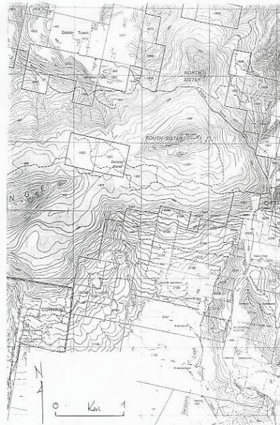
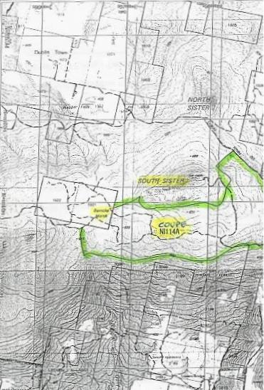
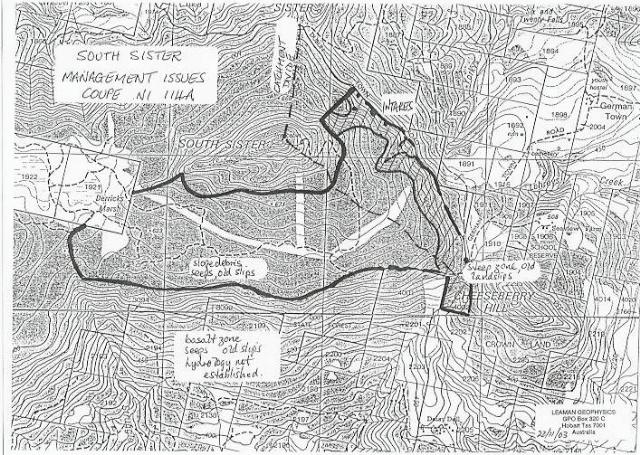
Coupe NI 114A, an area of about 165 ha, is located, principally, on the south face of South Sister - the eastern prominence of the Nicholas Range - above the town of St Marys. See Maps 1, 2 and 3.
Proposed actions involve 'thinning' the forest over a harvest
area of 108 ha situated on a shelf of gentler slopes on the south face
a little below the pinnacle, and an extension around the eastern end
of the mountain onto its northeastern face.
Despite numerous approaches by residents there has been no
modification of coupe planning which relates to land stability or
groundwater protection since May 2003 (Map 4).
The proportion of 'thinning' is defined as about 50% which means considerable snig and cutting activity across the entire area of the coupe (Map 5). The 50% figure does not refer to the surface area of the coupe but to 50% basal area removal of standing timber. Thus, snig cutting and machine activity can occur over virtually 100% of the 108 ha to be harvested. This is reflected in main snig track plans (Map 5). Variations in the intensity of activity within the total area will reflect the distribution and selection criteria applied to the trees to be felled. Some zones will be much disturbed. Plans do not indicate these variations nor relate them to water and stability factors.
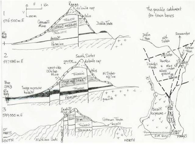
Dolerite, and its weathering and erosional products, caps the range and dominates the terrain. There are some minor exposures of the Triassic coal measures which underlie most of these deposits. The coal measures have been mined, but at moderate depth below the coupe. The geology of the site, however, consists primarily of slope deposits derived from the capping dolerite. The sedimentary rocks possess very shallow dips, generally to the south, but local variations have been recorded and may be related to faulting.
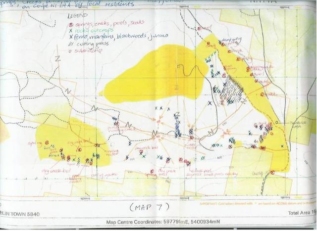
The upper part of the mountain, and the coupe area, contains numerous springs and seepages and some small marshes. Groundwater hydraulics dominates the hydrology of the coupe zone.
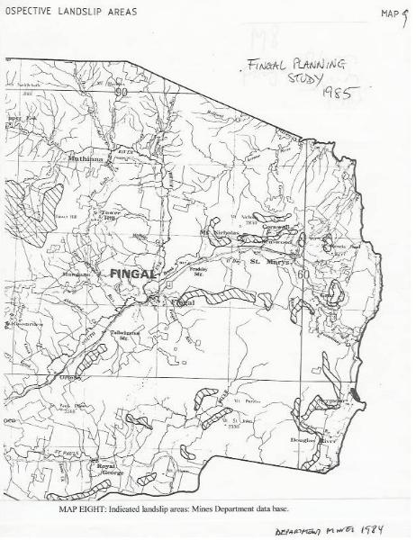
All upper faces of South Sister have a history of land and slope failure.
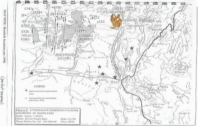
A critical level occurs at about 400 m asl where a layer of basalt marks the effective base of the Triassic succession and the top of the locally thin Permian rocks. Large faults bound the area of St Marys and South Sister and the largest extend north along the general position of Gardiners Creek between St Marys railway station (approx) and onto the Nicholas Range east of the Jubilee Mine. Smaller faults splinter from the main structure (Cornwall-Gould Fault System) toward Derricks Marsh about halfway between St Marys and South Sister and account for both the very broken nature of the ground for mining - and control of water transfer (see inset map, Figure 1).
The upper part of South Sister, above the German Town and Dublin Town Roads, provides water supplies to a number of local residents, some of whom distribute water from communal springs, while others generate electricity from these outlets. There is also a possibility that a significant part of the town supply for St Marys is generated, or stored, and transmitted from the South Sister area.
The issue is: what risks apply to these water supplies and how might those risks be varied as a result of the forest operations? And, as a corollary, are those risks sufficiently serious to counterbalance the value of the operations or to suggest that measures be undertaken which might minimise, or negate, those risks.
[some of the maps are not available on the website due to copyright reasons]
The use of the word, risk, implies that there are hazards which may threaten a status-quo and that some sort of gamble has been, or is being, taken with respect to current conditions. What is the nature of the hazard, and how might it be varied or managed?
1
The current landscape about South Sister, and its inherent hydrological system, is the result of natural processes - plus some variations induced by past human activity.
The present distribution of materials and their display is largely the result of peri-glacial activity and gross climate change in the last 20 000 years. Occasional seismic activity (vibration), extreme and localised weather events and patterns, and wild fire (plus aboriginal burning) have formed the set of natural hazards which have operated.
These intermittent hazard types coupled with continuous processes such as weathering have resulted in talus and debris drapes on the slopes, failures involving the capping dolerite, or the underlying Triassic coal measures and the surface drapes, and a particular form of water system.
Future risk to the landscape, and its form and hydrological system, thus involves new events of the type which have established the present condition. This is natural risk. Any element of the site may thus be changed by future events but the risk of this happening is low in human terms since the frequency, or likelihood, of a significant event is very low (many years) and most such events may be expected to cause damage only to relatively small segments of the area at any given time. Overall rates of change are, therefore, slow naturally.
2
The natural risk equation is usually transformed by human activity which may, in the case of forest operations, result in changes in slopes (e.g. excavations), revised drainage (side drains, culverts, diversions etc), alteration in soil or surface characteristics (changes in soil texture, compaction, exposure and changes in litter, light exposure, temperatures), exaggerated use of fire (intentional or accidental at frequencies which exceed natural return times) and total or partial clearing. These changes cause water and soil to be emitted or discharged in ways that differ from natural processes or volumes in the existing hydrological system. Such changes, alone or in combination with other events, magnify the likelihood of an induced event. Risks of damage, or change, are thereby greatly increased as a result of human intervention.
This risk is exemplified by the stability problems on the Nicholas Range associated with the active mining period when local changes in slopes, and alterations in drainage, led to many slope failures. This is normal response to human interference.
This response, and its universality, has been stressed by
observations made since the onset of road works in and around the
coupe - in early 2005. One pool area has dried, a new spring has
appeared and subsurface drainage has been affected by bank cutting and
tree removal, and absorption has varied elsewhere.
These changes to drainage systems, and disturbance of natural systems,
occurred within days of commencement of works, and there is no
assurance that all changes have yet been effected or manifest into a
new pattern. The changes are the combined result of vibration from
equipment, some soil disturbance, new drains and culverts, reshaping
of old drains, and general working - and the road works involve a
very small proportion of the coupe area!
3
There is need, therefore, to consider what further effects are
possible or probable, and their ramifications, given that thinning of
the forest cover must involve surface disturbance over a much wider
area than just the main road, changed drainage and water distribution
as trees are removed, and vibration from vehicles (on roads, and in
the forest).
Local residents are concerned that these actions, any or all of which
amplify natural risk factors, may affect their water supplies, so the
issue of possible damage becomes crucial.
Are the risks, and the potential damage, of greater import than feasible replacements or the value to be gained from the actions? This is a matter of relative value and replacement cost.
4
Appraisal must also recognise the unexpected factor.
The risk of failure (of slope, or water supply) may exist, the nature of actions and hazards may be known: what is rarely known is which part will fail, or fail first, or the scale of the failure or change. This doubt may be mitigated by extensive preliminary evaluation or investigation but it is never wholly removed. We are often surprised by what actually happens, and in what order.
There is also an element of the hair trigger: of how much activity or what scale of event drives damaging change. We may expect that the slopes of South Sister will fail again, since they have a history of it under natural conditions. What we cannot say, is when, and whether the next natural event (storm or earthquake for example) will cause it. It may take more than one event, or a coupling of events. Likewise, even when the risk factors have been amplified by human actions, we can still not know what the crucial threshold is. We can, however, expect that it will occur sooner that it would have done under natural conditions.
5
There are also unique local features which control the level of risk, or focus hazards.
Any action which affects such local elements has a proportionately greater effect on hazards, risk and potential damage.
6
The coupe occupies a portion of the upper mountain where slopes are
relatively gentle and generally less than ten degrees. Some of the
steeper slopes on the eastern end of the mountain have been excluded
from operations (Map 4).
North of the coupe the mountain is craggy and locally steep. South of
the coupe the slopes increase and definite drainage patterns are
developed.
7
Most, if not all, of the coupe area has experienced slope failure of some sort.
Failures evident include some which have involved the dolerite cap
of the mountain, the underlying Triassic coal measures, and the draped
debris.
It is not possible to date these previous failures but much of the
area has been fairly stable during the life of the existing
trees. This does not mean that there has been no movement: it simply
has not been catastrophic or obvious for the last few decades. This
probably reflects relative freedom from fire, logging and mining in
the last thirty years. Many blocks which litter the slopes represent
topples from higher levels on the mountain.
Some of the failure zones are very large and involve enormous
segments of rotated rock. Some rotated zones are hundreds of metres
long. The failure surfaces for these may extend tens of metres into
the bedrock of the mountain.
There is no clear correlation between nature of failure and scale of
failure, and the present slope angles.
The existence of previously failed ground means that the resistance to future failure is much reduced and the coherence and strength of the materials - including great portions of the apparent bedrock - is much less than normal. In these conditions future triggers for failure can apply at lower levels and on lower slopes than would be considered safe, or of low risk, in similar materials not so disrupted.
8
Future and further failure can be instigated naturally or by man-associated actions.
Natural failure is most likely to be associated with extreme weather events or area-wide fire. Management and control of excess water, or changes in water flow patterns (some of which may be altered by changes in ground cover or soil condition in the fire case), is crucial. Time of year and previous rainfall history (patterns and intensity in the weeks or months before another or extreme event) may make a crucial difference in the case of weather-related events. The water load and any pressure water conditions may trigger the final phase of failure. Less likely natural risk factors include earthquake somewhere in the region. The coupling of a vibration event and a weather event may induce failure when either event separately may not.
Human actions may be superimposed on natural effects but there are many changes inherent in human working. These include general ground disturbance, vibration (seismic or due to equipment), removal of vegetation (especially trees with deep roots), road making (cutting development and changed ground loadings), altered drainage patterns (whether due to changed vegetation or changed distribution due to ground disturbance, or new drainage patterns related to working), or fire (which may alter many factors).
Any slope failure or slope change is likely to have some impact on the water system.
9
The average annual rainfall around South Sister is estimated to be of the order of 1000 to 1500 mm, based on rain gauges nearby, but extreme events occur. Indeed, the St Marys and German Town region area holds a record for the most rainfall in a short time, for Tasmania. This variable rainfall pattern is typical of the upper Break O'Day catchment and the area is subject to large rain events and long dry periods. There is no consistent pattern to these and they may occur at any time of year. Existing records indicate that the worst time for extreme events is in autumn but the records are not long enough to establish firm conclusions or evaluate possible changes in pattern due to climate change.
10
Little obvious surface drainage is developed on the upper 200 m of
the mountain which demonstrates the significance and role of
groundwater in terms of the dissipation and absorption of
rainfall. Any surface flow which does occur (mainly as sheet run off)
is likely to be very intense and short term in these conditions;
especially when coupled with the style of rain events which
predominate.
The drape of surface debris, and its cover of vegetation, on the upper
slopes forms a key element in the recharge and infiltration process,
and water dissipation and flow control.
11
Many springs and seepages are evident around the upper section of
the mountain - as is to be expected in the general absence of clear
surface drainage land forms and the high infiltration potential.
The springs are related to several different features but can only
occur where the local water table intersects the land surface.
Some springs are directly associated with clearly failed and rotated rock sections, others are associated with the interface between surface drape material and underlying rocks (whether dolerite or coal measures). Relationships are indicated in Figure 2.
No information is available on the nature of the pathways which
feed the local springs, or their particular location in the
terrain. Some general comments can be offered. Springs are often
associated with large fractures (either in the rock mass due to
faulting or other tectonic activity), or failure zones which may have
more fractures. The fracture system, however generated in the bedrock,
is a critical determinant controlling the distribution, flow and
movement of water in the upper part of the mountain. Some indications
are shown in Figure 2.
While many springs involve the slope debris, and this debris is
important in terms of recharge to storage, the general water table is
not consistently within this material and consequently the debris
modifies outlets rather than acts as simple aquifer and supplier. It
does operate as infiltrating and recharge medium.
Springs are readily transformed, however, by disturbance.
In the simplest case this may mean a shift of outlet or a dispersal of outlet - which often renders the flow of less use and perhaps harder to collect. In the worst case, which is quite common, supply is cut off altogether - and the outlet lost. This is most likely where disturbance has affected part of the pathway fracture system which may be blocked or closed. In such instances water reaches surface elsewhere, or pressure may build up elsewhere. These changes are rarely predicted or predictable.
12
Since spring systems can be damaged, but rarely improved, by activity any disturbance should be avoided.
Natural processes - such as surface scouring or erosion, which alters the surface cover and mode of infiltration; tree blow downs which result in disruption of a pathway; earthquake which vibrates particulate matter into, or within, pathways; or fire which transforms many aspects of surface drainage, infiltration, erosion and so on - can change springs. Fire and earthquake can have general and widespread consequences whereas other processes tend to be minimal in effect and extremely local.
Human activity in an area - which involves widespread removal of trees and understorey; machine activity to reach and remove the trees which may alter surface compaction by loading and vibration, and so infiltration; and any intensity of fire which changes the surface cover - may transform the nature and distribution of springs widely, and at much faster rates.
13
Some particulate matter enters the hydrological system under normal
conditions but this rarely causes any problems. Such matter may be
broken down, dissolved, or held in the earth medium or fracture. This
can be considered as a filtering process. If too much is present then
the filter may block and flow is terminated or redirected. Where flow
is generally retained, the common experience, it means that any
material introduced has either been washed through or exchanged for
particles previously trapped.
No water system can be retained indefinitely if the ground medium acts
as perfect filter - since it would block and stay blocked.
The observation of fine particles near some spring outlets on South
Sister demonstrates that such particles are leaving the subsurface
system.
The further observation that some increased turbidity occurs at times
of rainfall either means that the additional flow and applied head is
introducing an abnormal particulate load, driving a clearance of
previous loads, or merely stirring up material near the outlet. It is
likely that all three effects occur but in different proportions at
different times of the recharge and flow cycle.
In abnormal conditions much particulate matter may enter the pathway system with the result that partial or total blockage does occur and the flow system is re-routed. This transformation is most likely during or after extreme rain events and is inevitable when bare soil is exposed, or much disturbed and some direct erosion is possible.
Forest working, which involves clearing of understorey, disturbance
or removal of tree roots, soil disturbance and exposure of soils, and
burning will, when coupled with a natural event (e.g., storm), impose
a particulate load on the water system.
The prescription in the Forest Practices Plan to 'minimise
disturbance' provides no indication of how this is to be achieved in
practice.
It is never possible to anticipate the nature of change to the hydrological system in these circumstances, but changes will occur.
14
Removal of vegetation may also have consequent effects with an uncertain magnitude.
Any change in vegetation cover results in changes in the water balances; involving evapotranspiration, and the recharge system. No firm rules can be assigned since research suggests that every area, and every catchment, has unique characteristics. Some general principles do apply.
It is common, but not universal, for there to be an increase in direct run off during and after the clearing phase in which considerable erosion may occur. This higher run off period may, if it occurs, happen with the first rain event only, or last several years. What is inevitable, however, is that during the regrowth phase there is increased demand for water above that level of demand which applied before any intervention, and this stage may last many decades. In some forest types the period of raised demand may exceed 150 years. It is not known how long this period would be at South Sister, or for the thinned proposal, but more than 60 years has been admitted by experts for Forestry Tasmania and DPIWE.
It should be noted that a fire may have the same result. A fire superimposed on a clearing operation would emphasize any effects.
The increased water demand, over and above current forest demand (which itself depends on the stage of recovery from any previous events), may range from 20% to 60% of available water; that which would normally have been released to run off or possibly to recharge. This amounts to a large loss to recharge or storage and will lead to the slow evolution of a new set of conditions and spring patterns.
15
It has been argued by Forestry Tasmania and the Forest Practices
Board that the maximum amount of water lost to regrowth demand after
clearing or burning operations amounts to some volume of the order of
50 to 100 ML per year for the coupe on South Sister. I agree with the
general magnitude estimated.
It is further argued by them that this volume is a very small fraction
of the amount of water delivered to the mountain each year as rainfall
(est. 5500 ML), the amount of water delivered to groundwater as
recharge (est. 700 ML), or the amount of water actually held in
general storage in the mountain (est. 20000 ML).
It has then been argued that since the proportion is so small that
the effect on the spring systems must be slight or negligible.
This is quite incorrect and is a deeply flawed argument which
ignores water table and spring reality.
Neither the volume of demand nor the volume of supply is relevant. The effect of the partial withdrawal is what matters. Where the volume is taken from, and what effect it has on the local water table, controls whether the existing springs can continue to function. Springs only function while the water table is at, or can reach, the land surface. A small difference in water table conditions can make an enormous difference hydrologically to springs.
Suppose the withdrawal due to forest operations is 100 ML and that
this loss is applied to the entire harvest area of the coupe, say 100
ha. Note that the calculation is worsened if the loss is applied only
to part of the coupe.
This volume of water is equivalent to a 500 mm change in water table
if wholly retained in the debris with porosity of 20% or a 2 m change
in level if within the fractured bedrock of 5% porosity.
Precise values are irrelevant, but are quite conservative here in
any case, since the crucial effect of the extraction by regeneration
is to either lower water tables or reduce storage on the mountain. Any
such change will affect springs: many will dry up. Which springs will
be affected cannot be predicted with existing observations and
data.
The calculation offered is based on average annual values as normally
quoted: but these ignore seasonal effects, droughts, or any changed
demands as may occur during growth season. Under each of these
conditions the effect of storage loss is amplified and the risk of
losing spring flow increased.
In the opposing short term condition, when extra run off may occur soon after clearing, recharge might be increased temporarily. This could lead to generally higher water tables than exist now, and to more springs and seepages, and higher flows from existing seeps. This view also presumes that water is captured in the changed and more disturbed conditions and does not run off, or is not led away by new drains.
Such possible raised flows are not likely to be long-lived (contrast with the long drawdown period to follow) but current experience around South Sister relates higher flows to poorer water quality - in the form of increased particulates or turbidity.
Some form of water damage is likely from the proposed operations - whether as more turbid or changed flow, and there is no guarantee in any event that the existing useful drainage sites and springs will be retained.
Long term climate changes may also lead to failure of spring systems due to changed rainfall or recharge patterns although vegetative response and demands may be interlinked. Superposition of human changes or demands on such natural changes, which mirror seasonal changes but are of much longer period, increase the risk of failure of supply or change in pattern of delivery of supply.
16
I also infer a linkage between the water stored on South Sister and the town supply at St Marys. This is based on six important FACTS.
This information suggests a storage and transmission concept which involves the South Sister storage and the general Gardiners Creek catchment as the principal agents in supply to the town water system bore. The existence of at least some defining information raises the concept from raw hypothesis toward a workable theory for full testing. See Figure 1.
The concept does not exclude some small proportion of supply being derived from the larger Break O'Day catchment but such supply could not provide the chemical signature, the volumes observed, nor explain the results at all test bores.
It seems likely that the idea of drilling a fracture zone trailing from the slopes of South Sister in order to obtain the necessary water was proven valid and that the supply was from the north. The original consultants for the town supply believed this to be possible: the results would seem to confirm their belief.
If this conclusion is indeed correct then any estimate of effect on
local supplies based on some area of catchment calculation involving
the entire region is neither valid, nor justified, and the role of
South Sister is significant. Clearly, any actions which affect
storage, supply head, disruption or blockage of the upper part of the
fracture system will have an effect on the town supply. The immediacy
of effect cannot be estimated but it could range from days to
years.
The implications cannot be dismissed out of hand: a substantial
investigation is required before such risks can be assessed or
disregarded.
17
Actions which affect the stability and condition of the landscape, and water movement across or into it, will have an effect on the general hydrology.
Proposed activities include roadworks, partial clearing (thinning), snig tracks and vehicular operation, and 'light' burning. All can have consequences for water take up and transmission and land stability. Any change in water movement patterns may contribute to changed risk of land failure and any change in stability can result in changed water conditions. The most immediate effect of such changes is likely to be seen at the springs (or loss of them) around the upper part of South Sister.
18
No adequate assessment of hydrological conditions has been undertaken - by anyone.
No adequate assessment of stability conditions has been undertaken - by anyone.
The actual level of risk involved cannot be properly estimated or quantified, yet.
Although various specialists and experts have commented upon the conditions at South Sister and the surrounding area no conference or discussion was called to establish any points of agreement or resolve issues of difference. Nor has there been any attempt to agree upon, or specify, an appropriate assessment regime in order to resolve any differences or arguments. Forestry Tasmania has relied upon internal review and assessment processes only.
Onus has, however, been placed on those who have had some aspect of their amenity or environment placed at increased risk to prove that it is not so. That onus should always rest with the agent of change who must show that risk levels remain no higher, or are lower, than before.
19
There are risks to the stability of materials and maintenance of water supply systems derived from South Sister. The natural risks are low, localised and unavoidable. All will arise at some point.
There are also risks to stability and water supply on South Sister due to the proposed forest operations. These risks will be superimposed on the natural risks and the effect of such interventions, taken in combination with natural trigger elements, increases the risk factors many fold. The results of taking such risks are not easily appraised at any time and are quite unpredictable in terms of scale and frequency given little knowledge of conditions and past history of changes. All that can be said with certainty is that changes will occur.
If issues of land stability, and especially water supplies, are deemed significant and to have commercial, environmental or amenity values then we may minimise the risks by avoiding un-necessary disturbance.
There is need to consider relative value and the replacement of, say, individual water supplies should the present supplies be damaged as a result of continuance of actions which clearly present an increased risk to those supplies.
Use of the term risk also requires consideration of the value of
what is risked and the chance of it being damaged, and to what
extent. There is then the further issue of what can or should be done
to minimise or mitigate the risk, or compensate for any loss or insure
against it. These are the fundamental questions of a risk analysis and
none of them have been considered in the planning process for South
Sister and the associated water supplies.
No one is presently in any position to say, or assure, that all will
be well.
These possibilities demand application of precautionary principles and a comprehensive and careful assessment of local conditions.
The involvement of groundwater, the invisible but dominant element of the water cycle, in all issues related to South Sister and St Marys water supply requires exercise of great care and responsibility since the factors which determine supply and its sustenance are never easily appraised. It is poor practice to accept such supplies, or hazard them, without the most complete assessment.
20
The Forest Practices Code is deficient in terms of spring and stream protection exclusion conditions and lacking in consideration for domestic, isolated communities or even small town water supplies - especially when these involve groundwater directly, or baseflow feed to streams. There are provisions for discretionary powers which would minimise or avoid risks to such supplies but these have not been applied in this instance. They should have been.
The certified Forest Practices Plan is contradictory in respect of town water catchments, and expresses uncertainty, such as 'it is unlikely' as to whether the forest operations will impact upon domestic or town water flows.
There is nothing in this opinion which is beyond my areas of expertise and I have made all enquiries which I believe are desirable and appropriate and declare that no matters of significance which I regard as relevant have, to my knowledge, been withheld from the Tribunal.
Dr. D. E. Leaman
May 8, 2005
6906 (1, 1, 11, 178)