South Sister St. Marys, Tasmania
A Review of My Experience as an Expert
Witness
in Weston & Others v Forestry Tasmania
by Ralph Rallings
The following attempts to summarise my experience in acting as an expert witness for the applicants in the matter of the effect of forestry operations on land stability within the proposed Coupe N114A on South Sister. This was my first experience in a forestry related matter. I have not been able to assess if I have experienced an aberration of normal practice or not. I thought, though, that there might be value in documenting my experience and putting on record some of my views. This review attempts to do this. It is concerned only with major issues relating to slope stability and mainly those in the NE facing slopes of the proposed coupe. The topics discussed include:
The summary also makes specific comments on the supplementary proofs of evidence (Ref 1) provided by Dr P McIntosh (an officer of the Forest Practices Authority FPA, engaged as a consultant by Forestry Tasmania) and Mr B Weldon on 28 September 2005. In my view, this particular report, which was intended as evidence to a Resource Management and Planning Appeal Tribunal hearing scheduled for the following week, is shown to contain false and misleading information on an issue central to the slope stability issue.
I started this review thinking that it should deal with technical issues. A more detailed discussion of technical issues is included in my Proof and Supplementary Proof of Evidence (Ref 2 & 3). Early on, I wondered how and why Forestry Tasmanian and the Forest Practices Authority (FPA) could take a stand that was so contrary to conventional wisdom on slope stability. It has been only since I have delved into the approval and appeal processes and the actual working relationship between these two entities that I have approached an understanding as to why this could be so.
I have worked in geotechnical engineering for over 40 years. I was a member of the Australian Geomechanics Society's Task Force the developed the standard national reference on landslide risk, Landslide Risk Management Concepts and Guidelines (see Ref 4), and I am a member of the current Task Force which is updating the Guidelines.
I provided evidence for the applicants (a number of local residents concerned about the potential impacts of harvesting on the coupe). My advice to them has been:
This advice is no more than conventional wisdom. For example, Geoscience Australia (Ref 6) identifies the removal of vegetation as a trigger for landslides, as does the Australian Geomechanics Society (AGS, 2000 - see Ref 4). Similar advice was provided by David Stapledon (Ref 7). David's expertise in engineering geology is recognized both national and internationally.
My involvement began in late January 2005, after the plan for the coupe had been certified, following a request from Dr F Daily of the Save Our Sisters Action Group to peruse the available information. I was particularly interested and concerned by the comment of Dr McIntosh (an FPA officer) (Ref 3) that:
"almost all parent soils on slopes in Tasmania have formed in the past by previous erosion under a different climate from that now prevailing and past failure is not necessarily an indication of present risk "
While the statement is accurate because of the inclusion of "not necessarily", it is misleading with respect to the risks posed by past failures. Past failures are probably the best indicator of present and future risk. I saw the matter in Perera's terms (see Ref 9):
"They (fossil landslides) commonly have developed under different climatic conditions and are not likely to move again under present climatic and vegetative conditions, unless human intervention tips the balance"
Being well aware that the removal of trees was one of the most common causes of landslide reactivation, I agreed to provide assistance to Dr Daily and visited the site in late Jan 2005. I found that there had been a history of land slides within the vicinity of the coupe and that no landscape mapping had been taken, either within or adjacent to the coupe. My report outlined the appropriate scope of further investigations.
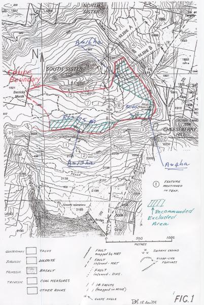
Attachment 1, originally produced by David Stapledon (Ref 7), locates two very large landslides (Slide A and Slide B) just above Dublin Town Road and near the northeast corner of Coupe NI 114A. Based on this figure, I recommended in my Proof of Evidence (Ref 3) that all of the eastern face of the coupe (Zone E on Figure 1) be excluded from logging. The location of the areas recommended for exclusion have been added to this figure.
The original investigations undertaken by Forestry Tasmania and the FPA had located Slide A and quite correctly removed the area of the slide from the harvestable area of the coupe. However, they failed to locate Slide B. Slide B is a very prominent feature. It is in the order of 5 hectares in area.
The subsequent position adopted by Forestry Tasmania and FPA experts has been that as there was no evidence of recent activity in Slide B, that it was an old slide on flatter terrain than Slide A and therefore:
I have argued that the removal of trees in areas of past instability is unnecessarily risky, due to the following issues:
Even in situations where it is considered that the risk of landsliding is low, there is no sound justification for increasing the risk of reactivation of a landslide by removing trees from landslide-prone areas2. The Australian Geomechanics Society (Ref 4, Appendix G - 'Risk Levels: Implications') states that activity in low risk areas is usually accepted subject to "treatment requirements and responsibility to define and maintain or reduce risk." (my emphasis).
Removing trees almost invariably increases the risk of reactivation of a landslide, therefore the removal of trees in landslide prone areas should always be avoided.
To be successful against Forestry Tasmania in the application before the Resource Management and Planning Appeal Tribunal, it was necessary to show that the forestry operations were 'likely' to cause a landslide. It seemed to me that the onus of proof was the reverse of what I would see as appropriate and fair. In my view, the onus of proof should have been on the agency causing the potential damage to show that instability was 'unlikely', however the onus was placed on the applicants to show that instability was 'likely'.
I was asked to advise whether, in my opinion, the proposed forestry operation was likely to lead to instability or to induce/reactivate landslides. On further enquiry, I was advised that 'likely' was best understood in a legal sense as "a real, rather than remote chance" of an event. This is the test that I tried to understand and to apply. The following provides a brief exploration of the meaning of 'likely'.
The Australian Geomechanics Society (Ref 4) identifies six levels of likelihood in relation to landslide activity. These are set out below, together with the indicative annual probability for each level:
| Description | Indicative Annual Probability |
|---|---|
| Almost Certain | 10-1 |
| Likely | 10-2 |
| Possible | 10-3 |
| Unlikely | 10-4 |
| Rare | 10-5 |
| Not Creditable | 10-6 |
Notes:
| Risk Category | Assumed Probability of Occurrence (50 year period) |
|---|---|
| High | 5% - 39% |
| Medium | 0.5% - 5% |
| Low | Less than 0.5% |
| Very Low | Less than 0.05% |
My 'gut' feeling was that the probability of reactivation of Slide B lay between about 5 and 20% based on the assumption that it was 'likely' to occur following an extreme rainfall event (1 in 50 to a 1 in 200 year rainfall event) during the 10 year period of increased water yield.
In my opinion, a probability of a slide in the order of 1 or 2% would seem to be "real, and not remote". However, I would caution that an approach based on estimates of probability is far too subjective and is unlikely to reduce disputes. Improved certainty will only be achieved by providing a sound and logical framework for investigations, recording and review. These matters are discussed in the following.
The degree of certainty that can be stated about a possible occurrence will usually be very dependent on the breath and reliability of the available information. Where the information base is poor, uncertainty creeps in. Events that could otherwise have been classified as 'likely' or 'unlikely' had there been adequate information end up in a 'possible' bin. By and large, it was uncertainty about the location of the Jubilee Mine that lead to the abandonment of the proceeding.
In my view, the forestry proponent (in this case, Forestry Tasmania) should bear the responsibility for demonstrating that its operations will not cause environmental harm as a prerequisite for certification. Forestry Tasmania has not demonstrated this or provided evidence that would support its case.
Requiring the applicants to show that the proposed forestry operations are likely to cause instability removes any obligation from Forestry Tasmania to demonstrate with objective evidence that the forestry operations are unlikely to cause instability. Indeed it could be thought that in matters of potential dispute, it would not be in the interests of Forestry Tasmania to record baseline data. By and large this is what has happened.
Forestry Tasmania should have carried out an initial baseline survey and:
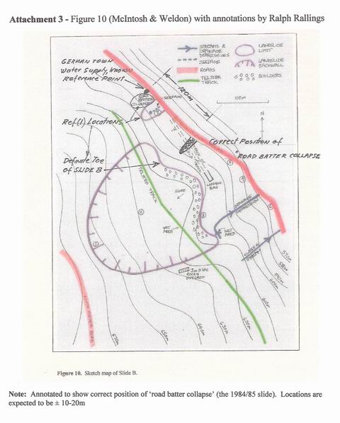
If Forestry Tasmania and its experts (including those within the FPA) were faithful to their belief that the answer to the assessment of risk lay in the activity of Landslide B, they should have undertaken detailed mapping of Slide B and the surrounding slopes. They have not done this. The extent of their mapping is displayed in Attachment 3 (Fig 10 of Ref 1). There has been no attempt to map the location and nature of slope changes and other landscape features, such as grabens and scarps, etc.
It is likely in a landslide the size of Slide B will no longer move as a single unit and that there will be a range of activity states within the slide. Inactivity at the head is no assurance that there is no movement at the toe. It is therefore important to systematically map each and every part of the slide. I appreciate that systematic and comprehensive mapping of the slide and its environs would be an arduous and costly task because of very difficult mobility on foot. However detailed mapping is essential if the decision is to be based on activity.
Exclusion of the slide and its surrounds makes a lot more sense.
It is generally recognised that it is unwise to interfere with a landslide unless its features and mode of behaviour are understood and that steps are taken to improve its stability. Understanding should involve the development of geotechnical models, including a reliable understanding of geometry and groundwater behaviour. No such information is currently available.
The probability of reactivation of a landslide is dependent on changes to groundwater levels, yet no evidence of current groundwater levels has been obtained or provided by Forestry Tasmania. Forestry Tasmania's experts argued (Ref 1) that I had failed to "demonstrate that a significant groundwater aquifer exists" - in my view, it is their responsibility to determine the extent of groundwater aquifers below proposed harvesting activities.
Personally, I do not favour going down the road of detailed investigations such as those outlined above. Such investigations will not achieve an appropriate degree of certainty and are frequently not worth the expense. Detailed investigations may be worthwhile where the potential benefits are large, say where avoidance might involve a significant increase in the length of a major road. In such situations attempts would also be made to increase the factor of safety by at least 20% through earthworks and drainage. However, in the situation of South Sister, the profit gained in recovered timber is likely to be small compared to investigation costs. The better course is to avoid the terrain where the instability has occurred.
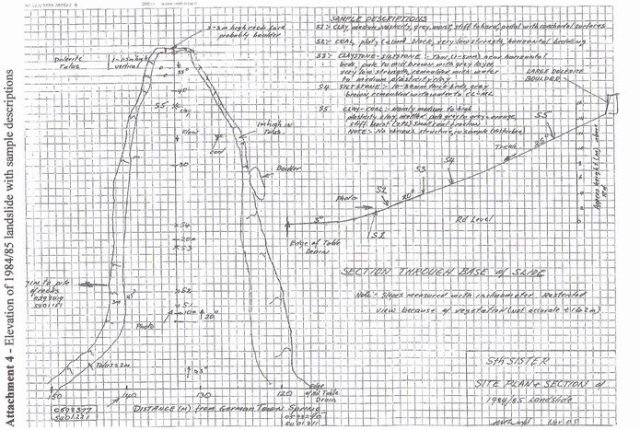
This evidence, provided on 28 September 2005, only a few days prior to the intended date of the Tribunal hearing, was confined to the locality of Slide B. It was not possible at that time to verify its accuracy. The authors conclude that "the landslide is a debris flow formed in a dolerite talus deposits with a slip plane probably on or just above the underlying sedimentary rocks." They also conclude that the slide is underlain by massive sandstone (Attachment 4).
I do not have any direct experience with debris flows, though I am acquainted with relevant reference material. On the basis of this information, I consider that Slide B is unlikely to be a debris flow as flows are generally linear features which move considerable distances at quite high velocities. If Slide B is in fact a debris flow, then it would be extremely unwise to disturb it in any way.
The following extract from a fact sheet produced by the Shire of Yarra Ranges (Ref 13), describes a debris flow involving 30,000 cubic metres or earth and rock which occurred on the north-west slopes of Mt Dandenong on July 12, 1891.
" it continued down the mountain at a speed estimated to be up to 40km/hr … flowed for up to two kilometres from the source landslip, with considerable damage being recorded over 1.4 kilometres ..."
What concerns me most about the supplementary report is the positioning of the 'road batter collapse' (as shown in Attachment 54 ) relative to the loading bay and the northern edge of Slide B. They have positioned the 'road batter collapse' about 160m from the loading bay which puts it outside of the toe of Slide B, when in fact this feature is less than 80m from the loading bay and well within the toe of Slide B.
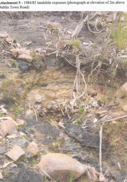
The 'road batter collapse' is in fact a relatively large landslide, reputed to have occurred in 1984/85 and to have blocked the road for several days. The scar of the slide is still evident in air photos taken in 2000. What remains on the ground is a steep sided hole, about 20m wide at road level, tapering to 4-5m at its head (which is about 45m slope distance) from the road. The depth ranges from about 1m to slightly above 2m. Water is seeping from the scar. The scar provides the best exposure of strata in the near vicinity of Slide B.
The location of this feature within the toe of Slide B puts an entirely different light on the nature of the slide, its activity, volume and the nature of materials in the slide compared to the picture provided in the report:
It is difficult to understand how two experienced investigators could so badly mislocate such a significant feature as the road batter collapse. Its position is critical with respect to the geometry and composition of the slide, and possibly to its actual activity. It also provides the best exposure of strata within the vicinity.
I have other difficulties, but secondary to the above, with their evidence. In particular:
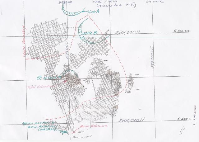
The relationship of the mine to the proposed harvesting needs to be clearly understood in order to assess the risks presented by the forestry operations. Attachment 7 shows the reputed location of the underground working with respect to Slides A and B, and Site 9 discussed by Stapledon (Ref 7). The mine entrance is at approx RL 500.
There have been various hypotheses about the impact of the forestry operations on the mine and vice versa. The landslide feature near the mine entrance (Site 8 in Ref 7) may be due to the mining. The trouble is that the elevation and slopes of the underground workings are not reliably known.
One theory is that the workings slope downwards, towards the south, and are at a relatively high level in the vicinity of Slide B. In consequence it is possible that Slide B may be well-drained and that any significant rise in groundwater is unlikely to occur as a result of forestry operations. This might be so, however there is no reliable evidence to support this. It is uncertainties of this kind, ones that cannot be resolved without intensive investigation that put an unfair burden of proof on the applicants
Drainage to the south, if this is occurring is likely to lead to increased instability of the slopes below Zone S. It is noted that an active slide (Ref 14 and Attachment 7) occurs near the mine entrance and that debris flows have occurred in the area in the past (Site 9 in Attachment 1). One local theory is that the mine is full of water. This, the reported instability near the mine entrance and the fact that the mine is over 100m above the valley raises serious safety concerns that require close investigation.
The concern here has been about the impact of the forestry operations on terrain below the coupe and not of the effects within the coupe. There is a landslide type feature within the proposed operations, (Site 8), probably the result of subsidence associated with the total extraction mining below. The focus has been on the slopes below the crest and on the mine (Ref 14). Nevertheless, the landslide feature should be investigated and excluded from harvesting.
It was argued by Forestry Tasmania that harvesting operations in this zone were unlikely to impact on the lower slopes because, essentially, the additional water is unlikely to reach these slopes I considered that this was not an unreasonable proposition, however there was little evidence presented to support the theory.
Believing that it makes good sense to err towards caution in the face of uncertainty and significant and untoward consequences, I suggested that it would be prudent to provide a buffer zone of about 200m placed along the proposed southern limit of the coupe. The location and extent is shown in Attachment 1. Its purpose was notional and aimed at soaking up lateral flows and also to provide some possible protection for the springs when water yields go into decline. I was also influenced by the thought that the cost of a buffer zone would be very minor compared to the rectification cost of any large-scale instability of the lower slopes. This suggestion, which was more about managing risk than technical information, was rejected.
1. Procedural Matters
In my view, there is an inappropriate and too close a relationship between Forestry and the FPA. I say this because it appears that FPA staff play a central role in investigations, yet these same staff are involved in the approval process. There should be a firewall between the two groups, Forestry Tasmania and FPA, and the two processes, investigation and approval of the forest practices plan.
It seems to me that the FPA officer in this case failed to identify Slide B at the investigation stage and from that point on it has been a case of defending the 'indefensible'. However, the 'indefensible' is very well protected under current arrangements because:
The system does not appear to serve Forestry Tasmania and the FPA well. While it may effectively squash objections, it is a recipe for hiding mistakes and inaccuracies. This leads to public mistrust and can undermine attempts to raise genuine concerns in the forestry debate.
In my view, there needs to be changes to the Forest Practices Code to ensure that all existing landslides should be excluded from forestry operations. The identification of a landslide should trigger an investigation of adjacent slopes. Adjacent slopes of similar geology, slope and aspect should be excluded. The Code should also deal with mines below coupes.
Minimum standards need to be set for geotechnical baseline studies and reports prepared for submission with the forest plan. This particularly applies to the appropriate detail of mapping and presentation of slope stability features and should be sufficient to show that instability is unlikely. MRT would be able to set requirements.
2. Other Matters
The latest information provided by Forestry Tasmania (Ref 1) contains a very serious inaccuracy, namely the incorrect location of the road batter collapse. It is serious because it seems implausible that two experienced professionals, working together and jointly preparing and reviewing the material, could mistake a distance of less than 80m for 160m. This is particularly concerning when the location had considerable significance for the argument. I must admit that it has left me with a considerable degree of mistrust.
There have been significant errors, such as the failure to identify Slide B and also to take into effective consideration the potential effect of a rise in groundwater levels on slope stability. These earlier errors were essentially omissions and could be attributed to simple oversight and/or lack of attention to detail. Some errors are almost inevitable in these matters because of haste and often because of a lack of technical or editorial review. It is difficult to excuse the recent error in this way and I believe that the cause of the error should be determined. It was, after all, intended as evidence to a tribunal hearing.
In my view, Forestry Tasmania has yet to complete a baseline investigation appropriate for a site prone to landslide activity. So much effort and resources have been spent on disputation because of a lack of factual information. Had they undertaken an adequate baseline investigation at the outset their costs would have been greatly reduced and most of the argument that has subsequently ensured may never had eventuated. Slide B would probably have been excluded. I believe that any delay or expense incurred by Forestry Tasmania should be attributed to the inadequacies in their early investigations.
I continue to believe that it is not wise to permit forestry operations within or adjacent to Slide B and recommend that the whole NE face of the coupe (see Attachment 1) be excluded from logging. The recommendation is largely derived from the application of conventional wisdom, a wisdom that was applied to Slide A and a wisdom that underlies the threshold slope angles of the Forest Practices Code
Notes
1Land (Ref 5) provided estimates of the expected change in water yield that would result from the proposed partial removal of trees from Coupe NI 114A. The water yield is the water available for surface and subsurface systems after evapo-transpiration. He estimated that this would rise by about 200mm immediately after logging and would then proceed to fall until the change went into the negative, 10 years hence. [back to mark]
2Risk is defined as "A measure of the probability and severity of an adverse effect to health, property or the environment. Risk is often estimated by the product of probability x consequence" (AGS, 2000). The AGS document contains extensive advice as to the estimation of consequence with respect to human health and property, but provides no advice with respect to environmental consequences. There needs to be some 'yardstick' to gauge environmental consequences, and without such a measure it is difficult to express environmental risk. [back to mark]
3The Forest Practices Code 2000 (page 53) provides that "Areas with slopes greater than the threshold angle will be assessed for landslide hazard by a soils or other geotechnical specialist before operations can proceed." However, in spite of locating Slide A, no investigation was carried out, presumably because the threshold angle of adjacent slopes was not exceeded. This matter needs to be addressed - the existence of a past landslide should trigger a hazard assessment of adjacent slopes, regardless of the slope angle. As discussed previously, a lower slope angle is not a safe indicator of improved stability (Ref 6). [back to mark]
4Please note, I have amended McIntosh & Weldon's Figure 10 to show the actual position of the 'road batter collapse'[back to mark]
Attachment 1 - Figure 1 - David Stapledon (annotated by Ralph Rallings)
Attachment 2 - Probability Plot - Indicative Probability of Occurrence
Attachment 3 - Figure 10 (McIntosh and Weldon)
Attachment 4 - Figure 10 (McIntosh and Weldon), annotated by Ralph Rallings
Attachment 5 - Figure 12 (McIntosh and Weldon) (27 September 2005)
Attachment 6 - Photograph showing exposure at road batter collapse
Attachment 7 - Reputed location of the underground mine workings (annotated by Ralph Rallings)
1. McIntosh, P.D and B. Weldon. 2005. Supplementary Report on Soil and Land Stability Issues on Coupe NI114A and Surrounding Steeplands (27 September 2005).
2. Rallings, R. 2005. Proof of Evidence - An Examination of Slope Stability Issues associated with the Proposed Logging Coupe NI 114A at South Sister (May 2005)
3. Rallings, R. 2005. Supplementary Proof of Evidence (September 2005)
4. Australian Geomechanics Society Sub-Committee on Landslide Risk Management. 2000. 'Landslide Risk Management Concepts and Guidelines'. Australian Geomechanics, March 2000. (Appendix G attached)
5. Lane, P. 2005. Scientific Review of Water Supply Impacts of Proposed Forestry Operations in State Forests Coupe NI 114A at the South Sister, North of St Marys. Consultancy Report for Tasmanian Department of Primary Industry, Water and Environment.
6. Geoscience Australia and Emergency Management Australia. 2003. Landslide Awareness. Joint pamphlet regarding landslide risk and management.
7. Stapledon, D. 2005. Geological Studies near South Sisters, Tasmania. Report prepared for Resource Management and Planning Appeal Tribunal Application A8/05
8. McIntosh, P.D. 28/11/2003. Comments on the report 'Appraisal of Initial Forest Plan on South Sister-Nicholas Range: hydrologic and landscape observations. D.E. Leaman, 22nd Nov, 2003'.
9. Perera, A. Nov 1992. Landslip Susceptibility in Tasmanian Forests. A Report to the Forestry Commission.
10. Moon, A and R Wilson. 2004. 'Will It Happen? - Quantitative judgments of landslide likelihood' Proceedings of Australia New Zealand Conference on Geomechanics. University of Auckland: (2) 754-760.
11. Weldon, B. 2005. Proof of Evidence (18 August 2005).
12. Weldon, B. 2005. Supplementary Proof of Evidence (September 2005).
13. Shire of Yarra Ranges (Building Services). Debri Flow Risk Areas: Special Considerations with Respect to Development in the Montrose Area. Fact sheet provided to residents.
14. McIntosh, Dr P. 2005. Proof of Evidence (including report on Land stability on Coupe NI 114A and adjacent steeplands)
6329 (1, 1, 8, 175)