South Sister St. Marys, Tasmania
An Examination of Slope Stability Issues associated
with the Proposed Logging Coupe NI 114A at South Sister
Ralph Rallings
ME. FIE(Aust). CPEng
Note: It has been assumed in this report that the current northern boundary of the harvestable area of Coupe NI 114A is the flagged boundary on the ridge between Landslides A and B and that previously it was north of Landslide A (based on maps in Appendix C).
The proposed coupe lies within a region of known slope instability and spring activity.
Forestry Tasmania's investigation of slope stability is of a preliminary nature and limited in
The slope stability investigation appears to have been under-resourced and under-skilled, being left mainly to one person. This comment is not intended to belittle the abilities of that person. It is intended to stress that investigations of slope instability, particularly where is intended to disturb landslide-affected areas, require a multi-skilled team effort.
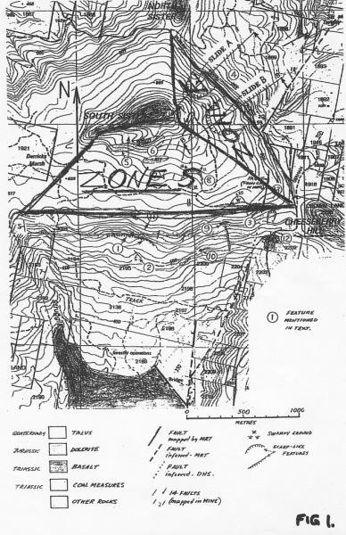
The stability issues on the eastern facing slope (Zone E in Figure 1) are different, in part, to the issues in the southern facing slopes (Zone S in Figure 1).
In Zone E, there are two quite major landslides (Landslides A & B - see report of David Stapledon, Ref 1). Logging on these landslides and on the slopes above them should not be contemplated. It is likely to increase groundwater levels and this may re-activate the major slides A and B. Soil disturbance associated with logging may also cause some reactivation within Zone E.
These major slides provide a strong indication that the adjacent slopes, which appear to be of the same geological origin, slope angle and aspect, are potentially unstable. It is my professional opinion that Zone E as shown in Figure 1 should not be logged.
It is not possible to be so definite with respect to the southern facing slopes within the coupe. The slopes within Zone S are not as steep as those within Zone E and, while expressing some possible signs of instability, I do not consider instability within this area of the Coupe to be of major concern.
The major issues about logging in Zone S concern the possible impact of the logging on the stability of slopes below the coupe. These lower slopes are often much steeper than the failed slopes within Zone E. Preliminary assessments have revealed considerable instability within these lower slopes. The impact of logging on the abandoned Jubilee Mine workings and the condition of the workings is not understood. It is argued that further investigations should be undertaken prior to any decision to log this part of the coupe.
My involvement in this study began in January 2005.
I reviewed a number of relevant documents, including a report from Dr P. McIntosh (see Ref 2). I was particularly interested and concerned by the following statement in that report:
... almost all soil parent materials on slopes in Tasmania have formed in part by previous erosion under a different climate from that now prevailing and past failure or erosion is not necessarily an indication of present risk'
While the statement may be accurate because of the inclusion of 'is not necessarily' it is quite misleading with respect to the risks arising from old slides. Past failures are probably the best indicator of present and future risks of slope instability. It was partly due to my concern about the above statement that I decided to visit the site on 29-30 January 2005.
Perera (1992, Ref 3) defines three classes of landslide activity: active, dormant and fossil. In his definition of fossil landslides, Perera makes the following comment on the risks associated with old slides:
'They [fossil landslides] commonly have developed under different climatic conditions and are unlikely to move again under present climatic and vegetative conditions, unless human intervention tips the balance'.
The existing landslides on Coupe NI 114A would probably be classified as dormant and as such would be more susceptible to human intervention than fossil slides.
I inspected the site of Coupe NI114A and surrounds on 29 and 30 January 2005. The report I prepared following this site inspection is included in Appendix A. Sites both within the coupe, adjacent to it and nearby were visited. This cursory investigation revealed:
Comments
2.3 Site Inspection of 12 - 14 April 2005
I undertook a further site inspection on 12 - 14 April 2005, in the company of David Stapledon (whose expert report of the inspection (Ref 1) has been submitted to this Tribunal). This further inspection caused me to largely dispel initial concerns about the significance of the tilted dolerite that lies above Zone S. However, my concerns about the stability of Zone E were increased by the positive identification of two large landslides in this zone.
The following section attempts to explain the causes of landslides and the role of the principal factors that contribute to slope instability. This discussion is intended to lead to an understanding of how slope stability issues should be approached and the skills and resources necessary to undertake reliable investigations.
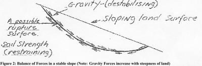
A stable slope is one where the shear strength along all possible surfaces through the slope exceeds the gravity forces that act to pull the land downwards on each and every conceivable surface.
Figure 2: Balance of Forces in a stable Slope (Note: Gravity forces increase with steepness of the land)
The most common natural cause of slope failure occurs when the shear strength falls. This fall in shear strength is in turn most often due to an increase in ground water levels. The reasons for this reduction in strength are discussed in Section 3.3.
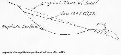
The sliding mass drops until it finds a new balance/equilibrium between the now reduced gravitational forces and the now changed restraining soil strength, as illustrated below.
Figure 3: New equilibrium position of soil mass after a slide.
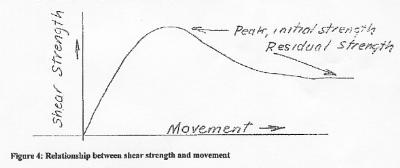
The sliding action commonly causes a marked reduction (can be as high as 50-70% of the original peak strength) along the surface of rupture.
Figure 4: Relationship between shear strength and movement
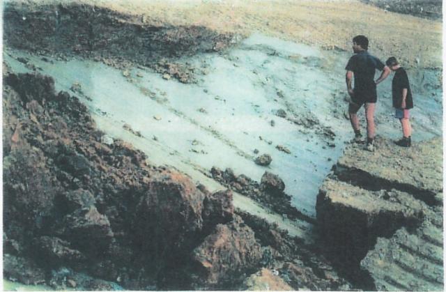
The soils along the surface of rupture commonly become quite polished by the movement. Photo 1 (attached), taken in a slide in Northwest Tasmania, illustrates the nature commonly occurring on rupture surfaces. These weak, polished surfaces appear to stay intact for long periods, possibly for hundreds of thousands of years.
In consequence of this near balance between the gravity and restraining forces, old landslides can be re-activated by relatively small-scale disturbances, such as an increase in groundwater levels or disturbance to the toe of the slide.
Comments
3.3 Effect of Groundwater on Slope Stability
The strength of a soil is measured in terms of its resistance to shear (i.e. one surface sliding over another). Shear strength is analogous to friction.
The force required to cause a mass to move, increases with the size of the mass and the roughness of the surface. In conventional mechanics/physics roughness is quantified as a Coefficient of Friction, whereas in geomechanics shear strength is normally quantified as a Friction Angle. The Coefficient of Friction approach is used in the following discussion.
The shear strength of soils, expressed as a Coefficient of Friction, ranges from greater than 1.0 for dense, coarse materials (such as gravels and boulders) to about 0.3 to 0.4 for first time failures in clays and to as low as 0.15 for the residual shear strength of some clays.
The force required to move the mass depends on the buoyant weight of the mass and not directly on the true mass. An increase in groundwater level reduces the effective weight, as far as the development of shear strength is concerned, by about 50%. For this reason, water levels are so important in matters of slope stability.
Landslides generally occur either during heavy rain or at some period afterwards because of the relationship between groundwater level, buoyant weight and shear strength.
3.4. Effect of Water Yield on Groundwater Levels
The paper by Dr Lane (2005, Ref 4) predicts an increase in water yield (in the order of 200mm/year) in the period immediately following the completion of logging (see Figure 5 of Dr. Lane's report). It is understood that this is equivalent to about a 40% increase in the expected yield of a mature forest (see Figure 5 of Dr. Lane's report).
The question addressed here is therefore: Assuming Dr Lane's prediction to be correct, what effect will this increase in water yield have on ground water levels?
The voids in soils above a water table, particularly clays, while not completely filled with water are nearly so. In most environments only small increases in water content are necessary to change the soil from a partially saturated condition (where there is no buoyancy effect) to a fully saturated one (where buoyancy effects occur as outlined above).
An indication of the relationship between water inflow into the ground and the consequential effect on groundwater levels can be gained from the 'Specific Yield' of various soil types (see Kiely, G, p202, Ref 5):
| Soil Type | Approximate Specific Yield% |
|---|---|
| Coarse gravel | 22 |
| Coarse sand | 25 |
| Fine sand | 10 |
| Salt | 8 |
| Clay | 3 |
Specific yield is the amount of aquifer water, expressed as a percentage of total volume that is free to drain under the influence of gravity. As such it provides only a crude indication of the likely increase in groundwater levels arising from a known water inflow.
A 100mm inflow into a soil with a specific yield of 5% is likely to increase ground water levels by about 2.0m.
The relationship between water inflows and actual water levels is very dynamic and beyond reliable prediction. In order to understand the relationship between inflow and groundwater levels it is necessary to monitor groundwater levels in boreholes over an extended period in conjunction with rainfall monitoring.
The rainfall records for Germantown (Appendix B) show a large variation in yearly and monthly falls. The slopes will be most vulnerable to instability in the years immediately following logging during or soon after high/extreme rainfall events.
Comments
3.5. Summary of Factors causing Landslides
In existing landslides there is usually a near balance between the gravitational (destabilizing) forces and the shear strength along the rupture surface. In consequence, any action that increases the net gravitational forces or decreases shear strength is likely to induce further instability.
An increase in groundwater levels will decrease shear strength and in consequence increase the likelihood of slope instability. It has been postulated by Lane that there will be increased water yields in the years following logging and as a result there is likely to be an increase in groundwater levels and slope instability.
The removal of trees within or above existing landslides should be avoided, as should any local disturbance of ground within the vicinity of the landslides.
Conventional wisdom is to avoid disturbing slopes containing existing landslides if this is at all feasible. In the event that there are very pressing reasons not to avoid such slopes, then quite detailed investigations would normally be undertaken. The scope and nature of these investigations are outlined in the following section.
The questions that should be addressed in relation to Coupe NI 114A and in all projects where slope instability is a possibility include:
4.2 Scope of Slope Stability Investigations
In order to understand the likely impact of a project/action on terrain it is necessary to understand the following factors:
The effective conduct of the above requires a wide range of knowledge and skills. It is now generally recognized that slope stability investigations require a multi-disciplinary team effort involving expertise in:
The last two fields of activity would often be provided by a geotechnical engineer, working in conjunction with a wide range of geotechnical service providers.
The development of a geotechnical model assists in the development of the understanding of the terrain and of the impact of the proposed projects/works on the terrain. A fairly wide definition of a model is provided below. A model (Ref 6) is an attempt:
'... to portray some aspect(s) of observed real world behaviour into a plan (figure, set of figures, equations etc) where the human mind can comprehend its behaviour, explore connections, discover hidden relationships and make tentative forecasts of the outcomes of these relationships'
The model has to be plausible at all practical levels of magnitude. This can span
Slope instability is a complex phenomenon. There are many 'unknowns' in geotechnical investigations. The 'knowns' and 'unknowns' have to be weighed and given significance. A modeling type process, which involves a continuing re-assessment as new information comes to hand, is an effective means of producing reliable outcomes.
Modeling is mentioned here in order to indicate that slope stability investigations are very dynamic and involve considerable interpretation and analyses.
4.3 Phases of Investigations
A slope stability investigation will often involve a number of phases. The first preliminary phase is likely to involve
The preliminary study should normally extend beyond the bounds of the project in order to gauge any possible impact of the project on the surrounding terrain.
At the end of the preliminary phase (which is the current status of planning for Coupe NI 114A), it should be possible to make a number of direction determining decisions
The scope of these further investigations is likely to include
For the purposes of this discussion the coupe can be divided into two zones;
Zone E and Zone S are marked on Figure 1.
The investigation undertaken by Stapleton (Ref 1) has identified two quite large landslides (A & B of Figure 1 of his report) on the east-facing slope, Zone E. Forestry Tasmania appears to have located only landslide A, but both are pretty obvious terrain features.
Forestry Tasmania has recognized that it is not prudent to log in the immediate vicinity of Landslide A and this area has been excluded in the Forest Practice Plan.
Applying the same, quite valid consideration, it would not be prudent to log in the vicinity of Landslide B, the ground between the two slides and the slopes above the slide, because of the increased risk of slope instability that will arise with the expected increased water yield from tree removal.
The whole of Zone E should be treated as potentially unstable and excluded from logging. This is based on simple logic. Slopes adjacent to the currently apparently 'stable' slopes of the same slope angle, geologicalsouthsister.org origin and aspect have failed in the past. Without clear evidence to the contrary, the 'stable' slopes are also at risk. As discussed earlier, to more clearly define the risks it would be necessary to undertake a thorough investigation, which would involve significant resources.
The issues concerning Zone S are different to the eastern facing slope. Whereas in Zone E there are clearly definable risks within the coupe arising from the existing landslides, the major risks associated with slope instability in Zone S are generally outside the coupe and at this stage are not so well defined.
There are similar risks to the landscape below Zone E as well and these would need to be investigated if logging was to be undertaken in this zone.
The key 'knowns' with respect to Zone S are
The key 'unknowns' are
It is recommended that prior to any decision concerning the logging of Zone S, detailed studies which address the 'unknowns' should be undertaken.
R Rallings, ME. FIE(Aust). CPEng
5/05/2005
Stapledon, D. 2005. Geological Studies Near South Sisters, Tasmania, Report prepared for Resource Management and Planning Appeal Tribunal Application A8/05
McIntosh, P.28/11/2003. Comments on the report 'Appraisal of Initial Forest Plan on South Sister-Nicholas Range: hydrologic and landscape observations. D.E. Leaman, 22nd Nov, 2003'.
Perera, A. Nov 1992. Landslip Susceptibility in Tasmanian Forests. A Report to the Forestry Commission.
Lane, P. 2005. Scientific Review of Water Supply Impacts of Proposed Forestry Operations in State Forests Coupe NI114A at the South Sister, North of St Marys. Consultancy Report for Tasmanian Department of Primary Industry, Water and Environment.
Kiely, G. 1996. Environmental Engineering, Irwin-McGraw Hill.
Farrands, J.L. 1993. Don't Panic, Panic. The Text Publishing Company, Melbourne.
Figure 1: Map showing Zones S and E
Figure 2: Balance of Forces in a Stable Slope
Figure 3: New Equilibrium Position of Soil Mass after Slide
Figure 4: Relationship between Shear Strength and Mass
Figure 5: Landslide Areas in St Marys Area (map produced by Mineral Resources Tasmania, based on report of Sloane, D. 1976. Further Investigation of Proposed Roads near St Marys. UR1976_40).
Photo 1: Example of a polished rupture surface, northwest Tasmania.
A: Coupe NI114A Landslide Risk Assessment, report prepared by Ralph Rallings following initial site inspection on 29-30 January 2005.
B: Rainfall records, Germantown
C: Maps showing coupe boundaries
Ralph Rallings
Principal Geotechnical Engineer
Education:
BE (Civil) University of Queensland (1962)
ME (Civil) University of Queensland (1966)
Professional Development and Memberships:
The Institution of Engineers, Australia
The Australian Geomechanics Society
The International Society of Rock Mechanics
The International Association of Engineering Geology
Previously both Secretary and Chairman of the Australian Geomechanics
Society, Tasmanian Branch
Awards Received:
Engineering Aware of Merit (Tasmanian Division) 2002
Countries of Work Experience:
Australian, Malaysia
Key Skills:
Ralph is a senior Geotechnical Engineer with over 43 years experience.
His interested have been directed towards investigation and problem
solving and the behaviour of earth materials and structures. He is
competent in many facets of geotechnology. His understanding extends
from large scale terrain behaviour to that of the constituent
particles of soils in environment ranging from tropical to semi-arid.
His areas of specialisation include road pavement technology
(including design, materials, specifications, construction quality
assurance), Geotechnical investigations (including route and slope
stability selection) and data reliability. He is recognised as a
national expert in these fields.
Ralph has been recognised as highly knowledgeable in soil physical behaviour arising from research into piping failures of earth dams and into the nature of reactions of lime and cement with clay soils.
During six years as a Geotechnical consultant with Coffey and Hollingsworth and later years with the Tasmanian Road Authority and Pitt and Sherry, he has undertaken significant investigation and geotechnical design for:
Ralph has contributed to professional knowledge in papers, Austroads publications and technical forums throughout Australia. In addition, he has been influential in the development of procedures for the investigation and rehabilitation of pavements as well as in the development of specifications for road construction and rehabilitation.
Geotechnical Engineering
| 1998-2005 | Principal Geotechnical Engineer - Pitt and Sherry Ptd
Ltd Specialist advice to Tas. Road Authority re stability and remedial measures for active landslips; Tas. Representative on IEAust/Aust. Geomechanics Society Taskforce on Review of Landslides and Hillside Construction |
| 1976-96 | Technical and Administrative Manager of the Materials
Branch of Department of Transport Tasmania Ralph was responsible for the geotechnical investigation, design and reporting for all State road and bridge works. The Geomechanics activities included:
|
| Feb '75 - Mar '76 | Monarto Development Commission, South Australia
Pedological mapping and subsurface hydrology studies concerned with
the potential impact of a new town on the Murray River. |
| Oct '71 - Feb ' 75 | Engineer, Coffey and Hollingsworth,
Adelaide From February 1972 to June 1973 seconded to Vallentine, Laurie and Davies, Kuala Lumpur, in charge of the geotechnical investigations for approximately 100 kilometres of intercity highways through terrain varying from marine and freshwater swamps to mountainous jungle. The Adelaide experience was of a relatively similar nature to Brisbane though the climatic and geological environments were quite different. The behaviour of buildings on expansive soils was an issue in Adelaide. Other investigations involved stability and dewatering analysis for a 140m deep open cut, a large industrial site and construction control at an oil refinery. |
| Mar '69 - Oct '71 | Engineer, Coffey and Hollingsworth,
Brisbane Consultant on geotechnical projects throughout Queensland and Northern Territory. Projects included road and railway route studies based on terrain mapping, stability of embankments on soft grounds, foundation investigations for buildings and large industrial complexes, container terminals, harbour facilities and hydrologic studies. |
| Aug '66 - Mar '69 | Australian Road Research Board Fellow to
University of Queensland Investigated the effects of moisture content, compaction and soil fabric on the properties of lime and cement stabilise clay soils. The study covered the chemistry of reactions, pore size distributions, swell potential and a range of conventional soil mechanics tests. Gave a course on soil physics to final year civil engineering students. |
| Jan '62 - Aug '66 | Irrigation and Water Commission, Queensland -
Farm Advisory Service Engaged on design of small dams and irrigation systems. From January 1963 to December 1964 seconded to University of Queensland as Water Research Foundation Fellow to investigate the phenomena of piping failures of earth dams in Central Queensland. Awarded Master of Engineering. |
| 1997 - 2005 | Pitt and Sherry Pty Ltd Technical adviser to the Department of Infrastructure, Energy and Resources (DIER) and its technical representative on pavement and pavement materials at various forums including
|
| 1976 - 1998 | Department of Transport Administrative and technical head of the Materials and Research Section. Principal Technical Adviser to the Committees and was a major contributor to a number of Austroads publications. Convenor of The Guide to the Visual Description of Pavement Condition and a technical editor of 'Statistical Assessment of Quality'. In 1997 joined the Australian Asphalt Pavement Association tour of the USA. The Technical roles covered:
Similar basic principles to that of Geotechnical Engineering were applied to Pavement Technology namely that appropriate solutions are best achieved by finding the relationship between the macro behaviour (e.g. Deformation) and the condition and properties of the constituent materials within the pavement. An awareness that the state of knowledge of the structural behaviour of unbound granular pavement materials was a major impediment to understanding the performance and capacity of flexible pavements has led to convenorships of Austroads Workshops and papers on these materials. |
| Feb 1972-1973 | Coffey and Hollingsworth, Malaysia Seconded to Vallentine, Laurie and Davies, in charge of geotechnical investigations for 100km of intercity highways. The pavement focus was mainly on the thickness design, the properties of potential materials sources and the development of construction specifications. |
In addition to the publications below, Ralph has been a regular contributor to local forums and IE Aust/AGS meetings
1. 'An investigation in the causes of Farm Dam Failures in the Brigalow Belt of Central Queensland' - Water Research Foundation, Bulletin 10, 1966
2. 'An approach to Subgrade and Materials Investigations for Low cost Roads - an ANZAAS Conference, Port Moresby, 1970
3. 'The effect of Pre-Treatment Moisture Content on the Properties of Cement and Lime Stabilised Clay Soils' - Australian Road Research Volume 4, No. 6, 1971
4. 'Swelling Clays in Water Handling Structures' Seminar on Physical Aspects of Swelling Clay Soils' - Structures, ASCE Volume 3, 1973
5. 'Piping in Earth Damn of Dispersive Clay' - Discussions in Performance of Earth and Earth-Supported Structures, ASCE Volume 3, 1973
6. 'Interpretation and Use of Relative Compaction' - NAASRA/ARRB Workshop on Measurement and Use of Relative Compaction of Soils, Aggregates and Asphaltic Concrete in Road Construction, Melbourne, 1982
7. 'A Guide to the Visual Assessment of Pavement Conditions' - Australian Road Research Board, 1985
8. 'Practical Issues in Rehabilitation' - Australian Road Research Board Seminar, April 1991
9. 'Issues in Materials and Geotechnology - A Place in the Sun' - Austroads Strategic Development Forum, Mach 1992
10. 'A Survey of Truck Tyre Pressures in Tasmania' F Chowdhury and R.A. Rallings, Road and Transport Journal, 1994, Volume 3, No. 3
11. 'Longitudinal Cracks in Pavements on Clay Embankments: A Study using Critical State Soil Mechanics and Finite Element Modelling' H.K. Tam and R.A. Rallings, Road and Transport Journal, 1995, Volume 4, No. 1
12. 'Seasonal Variations in Pavement Defections' R.A Rallings and F Chowdhury, Road and Transport Journal, 1995, Volume 4, No. 1
13. APRG Workshop 'Structural Behaviour of Unbound Granular Pavements; - APRG Working Document 97/03MA
14. 'Application of Quality control and Quality Assurance to Performance Specifications' AAPA Conference, Perth 1997
15. 'Unbound Granular Pavement Materials - Progressing towards a Performance Specification' APRG document 99/38 Oct. 1999
Austroads Publications:
The following are NAASRA and AUSTROADS state of the practice guides
which Ralph has had a significant role in authorship:
7555 (1, 5, 20, 46)