South Sister St. Marys, Tasmania
SUPPLEMENTARY PROOF OF EVIDENCE
RALPH RALLINGS
I have reviewed the Proofs of Evidence of
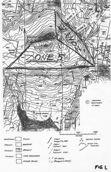
My review has concentrated on slope stability, particularly those associated with the east-facing slope-e (Zone E of Fig 1). Only two of the proofs of evidence contained new information in respect of these issues.
In my view, Mr. Weldon's analysis was seriously flawed because it overlooked the primary influence on slope stability, namely pore pressure.
Dr Laffan's report contained factual information on the composition and crumb stability of surface soils. The information provided indicated that the surface soils are relatively permeable with a relatively high resistance to erosion. The report included advice on appropriate erosion protection measures. I have no issue with this report.
Dr McIntosh provided details of recent investigations on part of the slopes below the southern facing slopes of the coupe (Zone S of Fig 1). These investigations supported the views expressed in the Proofs of Evidence of Dr Leaman, Mr Stapledon and myself that there was considerable instability in these slopes.
Dr McIntosh argues that the proposed harvesting above these slopes in Zone S would not have any significant impact on the lower slopes because, essentially, the additional water is unlikely to reach these slopes. I consider this to be a not unreasonable proposition, though one still lacking in evidence. The issues are about when reliance on reason should end and when caution should take over.
I believe that it is almost always wise to err towards caution, particularly when faced with uncertainty arising from incomplete information as there is in this situation. If harvesting is to be undertaken, I recommend a buffer zone at the southern edge of the coupe, wide enough to soak up lateral flows, to protect the unstable steeplands and springs below the coupe.
Dr McIntosh's report also identified an active landslide just to the west of the portal of the Jubilee Mine. This should be investigated further.
Concerns regarding instability would also be lessened if these lower slopes were quarantined from future logging.
With respect to the slopes within the harvest area of Zone S, I have no basis to claim that there is a real chance that the proposed harvesting will result in instability.
With respect to Zone E (particularly Slide B, as identified in Figure 1), there remains a wide gap between my views and those expressed by B Weldon, P McIntosh and W Erskine. Slide B is a very important consideration because
I contend that as a result of the proposed harvesting there is a real chance of promoting instability in Landslide B and also in the slopes below Zone E (which have been excluded from harvesting). The basis of my contention is that harvesting will cause groundwater to rise and that:
The authors of the proofs of evidence on behalf of Forestry Tasmania have not recognised that the factor of safety of an existing slide is likely to be close to 1.0. They have not recognised that a 100mm of additional inflow (or reduced outflow) is likely to equate to a 2000mm increase or more in groundwater levels, nor have they considered the quantitative impact of this increase in groundwater level on stability. The following misconceptions are evident in the proofs:
In conducting these reviews and compiling any earlier proof of evidence, I noticed a number of omissions and inconsistencies, including:
To determine and state with confidence that harvesting activities are 'unlikely' to cause instability on a feature of the size and disposition of Landslide B is a very challenging task; a task requiring finesse, the best information and detailed analysis. The fact that statements have been given without any detailed field mapping, modelling or quantitative analysis is rather extraordinary. There is nothing in the opinions provided in the Proofs of Evidence that would lead me to alter my previously stated opinion that:
This report is a response to the Proofs of Evidence prepared by:
The report focuses on slope stability issues and includes an analysis of the various Proofs of Evidence. Based on this analysis and review, I have made recommendations with respect to the stability of slopes within and adjacent to the coupe.
The following has used the zoning from my initial Proof of Evidence and the same identification of zones and landslides as shown in the attached Fig 1.
I have been asked to consider whether there will be a 'real but not remote chance' of instability arising from the harvest operations. I have applied this test in my report, along with conventional engineering considerations.
Much of the following concerns Slide B, which is located in Zone E.
Slide B is a very large feature. It is about 300m wide and about 200m from the headscarp to the toe. Its size tends to be lost on paper. To visualise it, it would occupy the area between Collins, Davey, Murray and Harrington Streets in Hobart.
Note: The position of the toe is uncertain, because there has been no detailed mapping of the slide.
The mass of soil and rock within the slide is probably about 1,000,000 tones. This large mass is thought to be resting on a relatively planar surface that dips eastwards at a slope probably between 10° to 15°. As an example, Mellifont Street in Hobart has a slope of 10° to 15°.
The following provides short comments on the Proofs of Evidence submitted on behalf of Forestry Tasmania. My comments focus on issues of slope stability and the related matters of groundwater levels and pore pressure.
This Proof of Evidence is the only one that attempts to look into the factors that cause instability. As shown below, the analysis is seriously flawed in that it fails to take into account the effects of a rising groundwater table (pore pressure) on stability. As discussed in my initial proof of evidence (Rallings, 2005), pore pressure (or buoyancy) is the dominant variable in slope stability.
Mr. Weldon concludes in the Executive Summary (p.2, para 6)
'The main effect of logging will be the addition of surcharge due to an increase in the weight of soil moisture that is expected to occur immediately after harvesting.'
The effect of an increase in moisture weight on slope stability is only a second or third order effect and would often be neglected in a quantitative analysis. Additional weight can either increase or decrease stability. The effect depends where the weight is applied:
Relative to the buoyancy/pore pressure effects, the impact of moisture weight increase is minor. A 100mm increase in water yield increases the average normal stress on the slide surface by 1kPa (0.1 x g). On the other hand an extra 100mm of water in a clay or rock with an air voids content of 5% (a much too high value for a clay or weathered rock near a water surface), results in
Pore pressure increase always reduce stability.
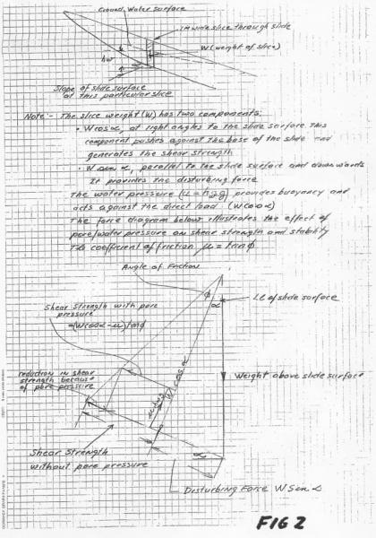
Figure 2 illustrates how water levels impact on shear strength and the balance between disturbing and restraining forces. In my view, the failure by Mr Weldon to deal with the pore pressure effect invalidates his analysis and conclusion that 'land movement is assessed to be unlikely.'
The risk analysis undertaken by Mr. Weldon is discussed in Section [4.4].
The report provides useful factual evidence about the properties of the near-surface soils. It indicates that the talus derived soils are relatively permeable with relatively stable crumb structures. The report (para 60) includes recommendations for erosion and sediment control. I have no issue with this report.
The following comments are concerned mainly with 'Land Stability on Coupe 114A and Adjacent Steepland' (3 August 2005), which forms part of Dr McIntosh's Proof of Evidence. The report contained new and useful information concerning the southern facing slopes below Zone S
A recent survey undertaken by Dr McIntosh on a portion of the southern facing slopes below Zone S has supported the observations made by Mr Stapledon and myself that the slopes have a lot of evidence of instability. Dr McIntosh attributes the instability largely to past mining and forestry practices. In my view, these past activities probably led to some of the instability but there are other large-scale features that would not appear to be of this origin.
Dr McIntosh considers that only a small percentage of the additional water yield is likely to reach these slopes. This might be so, however there is no evidence to support the assumption and it does not seem consistent with the occurrence of springs near the top of the slope.
Dr McIntosh concludes that 'it is unlikely that future disturbance of the NI 114A coupe area will affect stability of the surrounding steepland.'
There are no detailed cross sections or detailed evidence to support this conclusion. The stability of the slopes in the area below Zone S are discussed in section 5.
Dr McIntosh reported that there is a large and active rock slide just to the west of the Jubilee Mine portal. This should be viewed with concern as the mine is near horizontal and is reputed to be flooded.
With respect to Zone E and Slide B, Dr McIntosh contends that
'It is judged to be a very old feature and to be inactive.'
I do not agree with this statement, or the conclusion that Slide B and the surrounding areas should remain with the harvest area of the coupe. In particular, I note:
A further point of contention concerns the relative significance of the projected increase in water yield of around 100-200mm per annum and the variation in annual rainfall:
'which on the coupe can be 1000 mm above the mean (1116 mm). Under these conditions evapotranspiration and interception losses by the trees proposed for harvest will play only a minor role in decreasing rain fall infiltration and run off'
It is not disputed that rainfall, particularly prolonged rain over one to three months duration is the critical factor in stability. What is overlooked by Dr McIntosh, and others who expressed similar views, is that the two effects combine to increase groundwater levels. The antecedent ground water levels will be higher due to the harvesting and any effects resulting from the rainfall will add to this.
This Proof of Evidence provides no new factual data in respect of slope stability.
It is unclear if Dr O'Loughlin accepts Lanes predicted increase in water yield of 200 mm or believes it should be a lower amount. Either way, he recognises that the harvesting will cause a rise in groundwater and acknowledges the potential effect of groundwater levels on stability. The following extract from his text nicely illustrates the dynamics of the rainfall/evaporation and ground water regimes:
'Forest thinning on Coupe NI 114A will result in reduced evapotranspiration during the first several years, and thus an increased volume of water will be retained in the soil, and more will percolate to groundwater. This will generally raise ground water levels in the talus underlying the coupe, and cause the saturation areas at seepages and steam heads to expand.
Using an enhanced rate of percolation to groundwater of 100 mm per annum immediately after forest thinning (see above), then groundwater levels in the talus would rise by about one metre in a year (assuming a porosity of 10%). The cumulative increase over several years could exceed this, but the eventual rise in groundwater level would be limited by the increased discharge of subsurface water at springs and seepage areas. Nevertheless, pore pressures could increase where the talus is saturated, and marginally decrease slope stability. However, the actual increase in pore pressure would depend on the hydraulic conductivity of the talus deposits and the existence of preferred water pathways through them. (Higher hydraulic conductivity or preferred pathways have the effect of relieving or reducing pore pressures.) Because there is no information on the thickness, strength or water conducting properties of the talus, or its groundwater levels, it is not possible to comment on the significance (with respect to slope stability) of enhanced percolation of water into the talus after forest thinning'
There is much in the above which is pertinent and with which I agree. However, there are some matters which I would interpret differently and which have a significant bearing on slope stability. These are discussed below.
It would have been more precise to have used the words 'and decrease the factor of safety' in place of 'marginally decrease slope stability'. My contention is that existing, well-preserved slides will almost always have a factor of safety close to 1.0. As a consequence, a small/marginal reduction in the factor of safety (arising most often from a rise in groundwater level) can have a dramatic effect on stability (from a stable to unstable condition).
Clays, weathered rocks and rocks in the vicinity of a water table are likely to have air voids contents of well less than 5%, something less than 2% is probably appropriate and it could be far less in rock. Dr O'Loughlin's assumption of 10% porosity seems far too high. The issue is about available air space for the additional water to enter rather than total voids/porosity. However, the significant point is that the groundwater level will rise substantially and that stability will be reduced as a result.
The report includes no new factual data concerning slope stability. It includes argument that Dr Lane's predictions of increased initial water yield of 200mm is too high. Professor Erskine seems to be under a misapprehension with respect to landslides within the coupe. He states 'The proposed exclusion of steep lands and old landslides from the harvest areas are appropriate measures to address the landslide risk'
However, the large Landslide B remains within the proposed harvest area. At other places within his Proof of Evidence, Professor Erskine acknowledges that Landslide B is within the harvest area.
I have no argument about the importance of understanding those processes (climatic, tectonic, deposition, etc.) that lead to the formation of the current terrain. On a site like this one, I would always try to work with a competent engineering geologist and/or geomorphologist and to apply their observations, mapping ability and knowledge of these processes in the development of a geotechnical model.
Professor Erskine's assertion that
'[t]he standard and scope of McIntosh's (2005) assessments far exceed those required for a thorough and meaningful determination of the landslide risk associated with harvesting of Coupe NI 114A'
is completely inconsistent with the standards that he claims to be abiding by (Australian Geomechanics Society, 2000 - see Ref. 1). Table 1 of that Guide includes 'Methods which have been found useful to assess the likely frequency'. For deep slides in soil and rock, such as Landslide B, it includes the following:
Dr McIntosh has done little more than to locate Landslide B and to map a portion of the slopes below Zone S. None of the other levels of investigation have been attempted.
The analysis of B Weldon, by not accounting for pore pressure, is seriously flawed. Any conclusion reached is therefore unreliable.
None of the Proofs of Evidence looked at the question of slope stability quantitatively. No consideration was given to
Dr O'Loughlin was the only one to mention the relationship between increased water yield and increases in groundwater levels, yet this relationship is central to the slope stability issue. Dr O'Loughlin assumed porosity of around 10%. In my view, this is far too high and a value in the order of 2% or less would have been more appropriate.
The core point of contention is not so much about technicalities. It is about the level of investigation and analysis that is appropriate in slope stability assessment, particularly for a very large scale feature.
From my perspective, Landslide B is a large feature and its reactivation could have serious consequences. As discussed below, I consider that there is a real chance of reactivation, therefore avoidance is the safest course of action. I further believe that it is entirely inappropriate to reach any decision about Landslide B, other than avoidance, without:
None of the Proofs of Evidence have provided this level of information or come close to an appropriate level of assessment.
Dr McIntosh concludes that Slide B is inactive and Mr Weldon and Professor Erskine appear to have assumed that this was an established fact. There is no sound basis for such an assumption. There has been no systematic mapping of the slide or its surrounds and, as discussed in Section 2, there is evidence of relatively recent activity. It has also been assumed, quite incorrectly, that 'inactivity/dormancy' means that the slide is relatively safe and will not move as the result of the harvesting/ground water level increases. This assumption lacks due caution.
Slope stability and ground water levels are closely related. An increase in groundwater levels above a slide surface will reduce the Factor of Safety against slope failure by reducing shear strength.
The harvesting operations are predicted to increase the annual water yield over a period of between 'a few' (O'Loughlin, 2005) and '10 years' (Lane, 2005; O'Shaughnessy, 2005). The big and difficult question concerns the effect of this extra groundwater on slope stability. Related issues concern:
These issues are discussed in Section 4.2 below
The conventional engineering wisdom with respect to an existing slide is to avoid it and similar landscape unless there are sound economic (benefit to cost) or other pressing reasons to do otherwise. In this event it would be necessary to undertake detailed geotechnical investigations as outlined in my Proof of Evidence and then to design stabilising measures (such as drainage, buttressing, etc) aimed at increasing the Factor of Safety (under worst case conditions) by about 20%.
Conventional wisdom involves taking all practical steps to minimise water entry into the body of the slide. This will sometimes include tree plantings, within and adjacent to the unstable zone. Harvesting of trees within a slide is quite contrary to conventional wisdom.
The technical problem of taking actions that will notionally reduce the Factor of Safety of an existing slide is that there is inadequate precision within available methodologies to do this safely. Even with the most detailed investigations there would be too much uncertainty about the calculated Factor of Safety (say ±20%) to provide assurance that a reduction in Factor of Safety is safe. With existing slides, avoidance or significant physical works are the appropriate courses of action.
Recent activity in a slide indicates that the Factor of Safety is close to 1.0. However, it would be unwise to assume that the Factor of Safety of an 'inactive/dormant' slide is substantially different from 1.0.
The past sliding action can create a new geometry for the slide and additional planes of weakness. Some zones within the slide will have different 'activities' to other zones. In Slide B, the active zones are likely to be within the steeper slopes, immediately below the coupe. Removing these steeper slopes from the coupe does little to ensure their stability (except against near surface slides) if harvesting is undertaken within their ground water catchment areas above the slopes.
There is an approximate relationship between the height of groundwater above a slide surface and the soil strength generated at the surface.
The shear strength on the slide surface (rock or soil) of an existing slide is directly proportional to the stress (load) on the surface. This stress on the surface is proportional to the weight of soil/rock above the slide surface after buoyancy effects of the ground water are subtracted. Figure 2 illustrates how groundwater levels affect/reduce the restraining forces/shear strength.
If the shear strength is 'χ' when the groundwater surface is at the slide surface, it will be
A 1 m rise in groundwater levels at a point where the depth to the slide surface is 10 m will result in a 5% reduction in shear strength. A similar reduction occurs for a 2 m rise in a slide depth of 20 m. Changes of this order may be enough to destabilise many existing slides.
The groundwater level will be affected by the pattern of rainfall as well as the physical characteristics of the soil and rock masses.
The harvesting on Coupe NI 114A is expected to cause groundwater levels to rise. The amount that the 'permanent' water table rises over the first several years cannot be predicted (see Dr O'Loughlin, 2005) but level rises in the order of 1 to 5 m are conceivable. A significant rainfall event during this period of the raised 'permanent' water table has the potential to trigger the reactivation of Slide B. This is a 'real' possibility not a 'remote' one.
When a slope fails, the sliding mass will continue to move until a new equilibrium is established between the disturbing and restraining forces, that is the Factor of Safety = 1.0
Factor of Safety = |
Restraining forces |
The new equality between the two opposing forces is likely to remain in perpetuity unless:
Old slides could be expected to have been exposed to extreme rainfall events, and the current stability is likely to reflect this. The factor of safety of old slides could be expected to be slightly greater than 1.0. In consequence a relatively small reduction in shear strength, say 5% or thereabouts, may reactivate the slide. As discussed above, a 1 m rise in the ground water level in 10m of soil/rock will result in such a drop in strength.
The point here is that existing slides can be reactivated by relatively small increases in ground water levels.
Appendix G of Ref 1 (attached) provides a qualitative base to estimate risk to property. Risk is essentially the product of likelihood and consequences.
It is important to understand that the approach is notional and far from precise. The procedure is useful in helping to establish in which 'ballpark' the matter lies. The estimate should be based on specific information on the site and surrounds.
Comment: The procedure set out in Appendix G is currently under review. I was a member of the original task force for the AGS document and have been asked to be on the newly reconstructed National Disaster Mitigation Program Landslide Taskforce which will review the AGS document. Preliminary information provided to task force members has shown that the current Appendix G is open to wide interpretation. This becomes fairly obvious when one tries to use the methodology.
The following provides my estimate of risk using this procedure and comments on the reliability of outcomes using this procedure and on the estimate of risk.
Ref 2 nicely summarises the evidence on which likelihood should be based:
'The evidence ... has to be assembled, understood and interpreted. This process involves developing a slope model that reflects a sound knowledge of how the slope was formed, how it behaved and how it might behave in the future.'
There has been no systematic survey and frequency analysis undertaken of landslides in the region, but it is known that there has been a lot of instability (as reported in my Proof of Evidence). I have based my assessment of likelihood on the regional evidence of slope instability, the assumed low factor of safety, the configuration of the slide and on limited evidence of its activity (Stapledon, 2005).
As the raising of groundwater levels is one of the most effective ways of destabilising a slope, I believe that harvesting within and adjacent to Slide B, in conjunction with an extreme rainfall event is 'likely' to destabilise Slide B.
Mr Weldon rated the risk of a landslide as 'unlikely'. This roughly equates to a recurrence interval of about 10,000 years. His conclusion is not surprising in view of the fact that the most probable cause of sliding (rising groundwater) was not considered.
Consequences will be related to the distance and speed of travel. There has been no assessment of expected travel or rate of travel of Slide B.
The draft documents supplied to the AGS task force members has stated that users have found the current description in Appendix G to be open to wide interpretation. Consequences could be argued from three different perspectives:
From the damage and inconvenience perspective, the following might apply:
The cost of stabilising works for Slide B is likely to be well in excess of $0.5 million. The investigation costs alone might well exceed $0.1m.
From either of the above perspective it is hard to avoid the conclusion that consequences of slide activity could be 'medium' or 'major'.
Comment: One option currently under consideration is to define categories in terms of the cost of damage and reinstatement, relative to the market value of the property. A corollary of this approach would be to compare the cost of damage caused by a slide together with the cost of stabilisation against the value of the harvested timber. One of the current drafts under consideration rates consequences 'catastrophic' if the damage/cost is greater than 75% of the market value of the property.
Using the risk matrix of appendix G, a likelihood of 'likely' and consequences of either 'major' or 'medium' leads to a 'high risk' category. Even if it was argued that the consequences were 'minor', the risk category according to the matrix is still 'moderate'.
Mr Weldon used this procedure in the most subjective of ways. He did not approach the assessment from site specific information and failed to consider the most important influence on slope stability. He reached the view that the risk of harvesting on Slide B was 'low'.
Appendix G gives examples of the implications of the various risk categories. They set the appropriate scale of investigation, planning and risk evaluation. An examination of the table will show that risk reduction should be part of all strategies in risk categories from 'very high' to 'low'. This is little more than plain common sense. Mr Weldon concludes that because the assessed risk (by his flawed assumption) is low, harvesting is 'acceptable'. This conclusion is not consistent with a risk reduction strategy.
Increasing risk by removing trees is not a viable risk-management option.
There is no identified major stability issue such as a major landslide within this part of the proposed harvesting area.
The major issue raised in my initial Proof of Evidence concerned the impact of the proposed harvesting on the steeplands below and south of Zone S. The concern was mainly about unknowns and uncertainty.
Mapping undertaken by Dr McIntosh has supported views previously expressed by Leaman (2004, 2005), Stapledon (2005) and myself that the slopes below the coupe have many signs of instability. He agrees, however, that there would be no significant movement of water arising from the increased water yield within the coupe on to these lower slopes and that the stability of this steeplands will not be compromised by the proposed harvest.
Dr McIntosh has presented a schematic section (his figure 3) which shows the expected stratigraphy and water flows but there are no sections based on actual topography and subsurface conditions. I believe that his conclusions, though speculative, are not unreasonable.
The additional water yield in Zone S has many potential pathways. I suspect that it would be very difficult to establish the pattern of water flows and the impact of increased water yields on these flows. A significant proportion of flow is likely to be downwards, but probably not all. There are a series of springs near the crest of the slopes. The source is likely to be within the harvest area. It is likely that some of the additional water yield will find its way to the unstable slopes.
I could not argue that a small amount of additional water, emanating from springs has a 'real' chance of promoting additional instability. In my view, it is likely that landslide and debris flows will occur in the southern slopes, with or without the proposed harvesting. I also suspect that the harvesting will exacerbate the instability, but I can not estimate to what degree.
I believe that it is almost always wise to err towards caution, particularly when faced with uncertainty arising from incomplete information as there is in this situation. A large buffer zone at the southern edge of the coupe would seem appropriate. I have no quantitative basis to determine its appropriate width, however it should be wide enough to soak up lateral flows from the harvest area and to protect the spring from future yield reductions. Notionally, a buffer should be in the order of 200m wide.
If the edge of the crest was defined as the 590m contour, the excluded area is estimated to be approximately 15 hectares.
Even a remote chance that the harvesting could increase instability around the Jubilee Mine entrance should be taken seriously and further investigated. The occurrence of a large landslide close to the mine entrance, as reported by Dr McIntosh, is of concern. There are also suggestions that the Mine may be flooded. The collapse of the Mine entrance could possibly release a large volume of water onto an unstable slope with potentially catastrophic outcomes. Therefore, I believe that there needs to be a detailed study of the Mine.
The very unstable slopes below the Figure 1 coupe should never be logged.
In my initial Proof of Evidence I recommended that there should be no logging within Zone E. I still hold that view and with an equally strong conviction. The evidence provided by Dr McIntosh and Mr Weldon has provided no new facts about the stability of Slide B or the stability of the remaining areas within the coupe or the steep areas below the coupe. In my opinion, there is a real chance that the harvesting will promote slope instability within the coupe and in the slopes below the coupe.
Within this zone there are two major landslides, Slide A and Slide B as located in Fig 1. The occurrence of Slide A was recognised by McIntosh in 2003 and, although it was described as inactive, has been excluded from the harvest area and a buffer zone created around it.
The occurrence of Slide B was not identified by Forestry Tasmania until March 2005, following evidence presented by Stapledon. Though the slide is now identified, Forestry Tasmania has included Slide B in the harvest area of the coupe on the basis that it is now inactive and does not require a buffer zone.
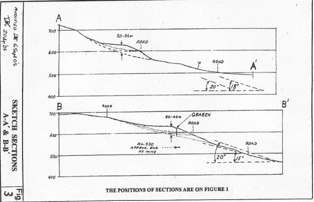
In considering if Slide B and its surrounds should be harvested or not, it is important to remember that it is about 1,000,000t of soil and rock which is sitting perilously on a long, relatively steep slope (see Fig 3).
There has been no detailed mapping of the slide or surrounding areas and until this is done the full picture about its current state of activity is not clear. The presence of a graben type feature as reported by Stapledon (2005) suggests that it may not be inactive.
The appropriate course of action is to avoid disturbance in this area. Even if quite detailed mapping showed that the slide was 'inactive', it should not be logged. The fact is that the Factor of Safety of Slide B will be close to 1.0 and that a small reduction in the Factor of Safety, caused by an increase in groundwater levels, could trigger movement. The chances of this movement occurring are 'real' and far from 'remote'.
The fact that Slide A is in steeper terrain than Slide B may only indicate that the ground conditions at Slide B are the weaker. While Slide A is a more prominent feature than Slide B, Slide B is still a very prominent feature. There is no sound basis to treat these slides differently. both should be excluded from the harvest area and provided with buffers.
There should be no logging on or above Slide B. This would exclude approximately 10 - 12 hectares.
It is unclear if the slopes within and below Zone E have been examined in detail. The fact that such a large feature as Slide B was not identified in the original (2003) studies suggests that no detailed studies were undertaken. The recent survey by McIntosh (2005) was directed to the northern end of Zone E.
Harvesting within Zone E is very likely to increase groundwater levels both within the harvested zone and on the steeper lands below the coupe. The area below the coupe has already been recognised as unstable. Removing these lower, steeper slopes from the coupe might afford some protection against surface slides, but not against deep seated slides.
The ridge between Slide A and Slide B is relatively vulnerable to instability. Slides A & B have occurred on both flanks leaving the ridge without side support. There is less restraining friction on a ridge from the edges of a potential slide, relative to slides in a uniform slope or gully.
A further consideration is that Slide B has occurred on slopes similar to those to its south. Lower slopes do not necessarily mean less risk:
'Landslides are commonly more likely on flatter slopes of an escarpment because the flatter slopes may include past landslips, areas of thicker soil, and/or some other less favourable combinations' (Ref 2)
The small remaining area to the south of Slide B is suspect with respect to its stability. There is a real chance that harvesting in the remaining portions of Zone E will destabilise the steeper slopes below the coupe as well as those within the coupe. In my view, Zone E should not be harvested. This would exclude a further 10 - 12 hectares, with the southern limit defined by the catchment boundary.
R. Rallings
8 September, 2005
Figure 1 - Zones E and S
Figure 2 - Illustration of the impact of water levels on shear strength and the balance between disturbing and restraining forces
Figure 3 - Sketch Sections A-A' and B-B'
7583 (2, 5, 22, 171)