South Sister St. Marys, Tasmania
Supplementary Proof of Evidence
David Stapledon
In my proof of Evidence dated 8 May 2005 (Stapledon, 2005a) I reported on two major landslides (Slides A and B) on this slope, and formed the view that appropriate more detailed studies would show that most of this slope had been affected by past landsliding, significant in the context of the proposed logging. I came to this view after careful consideration of the following:
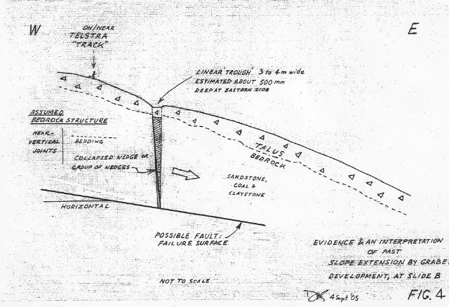
Regarding point 4, despite the rain and mist on 14 April 2005, the shallow trench forming the evidence for the Slide B graben was recognized easily from 20m upslope. Its sides are no longer sharp and it has probably been partly infilled. It looks like a shallow box cutting. I considered and discounted possible man-made origins - part of Telstra's track, or a bench made during past logging. It appeared so well preserved that detailed studies of it may indicate a relatively young age for the youngest movement at this slide - perhaps not much older than the oldest trees.
In the light of all of the above, I wrote (Page 2, Para 3 of Stapledon 2005a):
'I suspect that careful studies will find that most of this northeastern slope, from the Cardiff Mine corner, to the North Sister corner, has suffered some past landsliding. In my opinion this should be investigated thoroughly before any forestry operations are allowed'
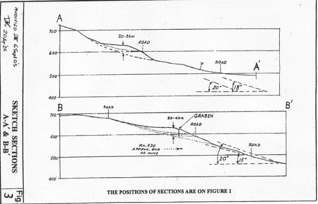
Although Mr. Weldon states on Page 5 that he visited the Coupe for 3 days, his report contains no evidence that during that period he carried out any geological or geomorphological field work in this critical north-eastern area. I find it incredible that any engineering geologist, having read my report, would have failed to critically examine and report on, the graben evidence, at least. I was surprised also by his concern about tree roof effects on a rockslide (pp.21-22) and his use of Sketch Section B-B from Figure 3 of Stapledon, 2005a to calculate depths to the nearest 0.1m.
Mr. Weldon's report provides general material on landslides and an assessment of the risk of renewed movement at Slide B. His emphasis on 'surcharge' suggests a misunderstanding of the main detrimental effect of additional water on the stability of a slope. I understand that Mr. Rallings has commented on this issue, as it is in his principal area of expertise.
Except for his review of old drilling records (at p.23), and his observation of Triassic rocks along the Dublin Town Road, Mr Weldon provides no relevant personal geological or geomorphological observations about the site of Slide B.
Despite all of the above, Mr. Weldon uses a ranking system of stresses and strengths to support his conclusion (p.23) that the risk of land movement on Slide B is low, after the proposed selective logging. I disagree with this conclusion and question the validity of the way in which it was reached. My own views on this issue are given below in 1.5.1.
Mr. Weldon has not addressed the question of potential instability of the whole northeastern slope.
Dr. McIntosh advises that he has visited the proposed Coupe 6 times: 5 times for one day and once for two days. On his first visit in 2003 he identified the features now referred to as Slide A, and considered them to be inactive, because 'there was no evidence of fresh scarps, hummocky ground, soil cracks or distorted trees'. However, he recommended that the slides be excluded from the harvest area:
'as a precaution against the possibility of further movement, to protect the steep backwall areas, and also to protect the quality of the domestic water from a pond situated in the basin of the Lower landslide'
In a footnote, Dr. McIntosh admits finding 'distorted trees' on the main scarp, during his most recent visit, in May 2005, and refers to Figure 15 (p.24).
I agree with the decision to exclude Slide A from the harvest area. I note that the distorted trees shown on Figure 15 would have been just as clearly evident in 2003 as in 2005 and that they reinforce my view of the potential for renewed instability in the northeastern slope.
Figure 16 description and Site C3 text (p.24) - This photo of Slide B cannot be looking north, as the backwall faces to the northeast. The steepest ground surface slopes are actually around 20 to 25 degrees, on the displaced mass, above and below Dublin Town Road. I agree that the trees are nearly all straight. In my short inspection, I saw no signs of present activity but I disagree that the subdud upslope landform is necessarily an indication of a 'very old feature'. Even if it was originally developed in periglacial conditions, this does not exclude the possibility of its subsequent reactivation. Mr. Weldon admits this, for slides in Launceston and Hobart, in Para. 3 of Page 23 of Weldon (2005).
I have worked on 2 major projects in New Zealand involving many such very old landslides. One of these was the Clyde Dam project (see Stapledon 2005a, Appendix W2) where detailed studies during construction of the dam wall found that about 20 of the slides were moving very slowly (creeping). At this project, 114 million dollars (NZ) were spent on site investigation and drainage to stabilise the slides. The slides had been recognized years before the site for the dam and reservoir was chosen, but academic geologists convinced the planners that they were stable and would remain so because of their very great age and origin. The slides would have been avoided if the dam had been located upstream of them.
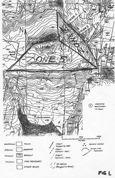
Figure 13 (p23) and Site C4 (p24) - Figure 13 shows the position of three or four features along Dublin Town Road, which he refers to as 'shallow slips' and as 'debris flows resulting from road batter collapse after road-building'. I have plotted these features as bold black dots onto my Figure 1. The most northern of these features is at the domestic water intake or 'Germantown Spring' (which was labelled Feature 15 in Figure 1 of Stapledon, 2005a but not described in the text). This small slide appears to me to have been caused by a relatively young movement at Slide A. I also consider it possible that the other three 'slips', to the south of Slide B outline, are also related to more deep-seated (creep) movements in the bedrock.
In 9.1, Dr. McIntosh states 'One rock slide (rotational slump) within the harvest area is judged to be very old feature and to be inactive. Coupes with similar slopes, soils and geology have been harvested without detrimental effects on soils, land stability or water'
These sentences obviously refer to Slide B. As noted above, I disagree with Dr. McIntosh's conclusion about the age of this slide. The age of the first movement is not relevant, if there is evidence (such as the graben feature) of younger movement. I have not seen any evidence to support his statement in respect of similar coupes.
Professor Erskine's principal expertise is in geography and riverine studies. In my opinion, he has insufficient experience in geology or rockslide matters to justify the highlighted parts of the following paragraph (at p3 and repeated at pp.37-38):
'The role of rainfall in generating landslides at South Sister cannot be unequivocally determined from the present data because of the lack of a detailed landslide history and the lack of a long-term rainfall record of adequate quality at an appropriate location. This is a common situation in Australia (Erskine, 2005) and highlights that the standard of risk assessment completed by McIntosh (2005) for Coupe NI114A is thorough and appropriate for the level of currently existing information (Australian Geomechanics Society Sub-Committee on Landslide Risk Management, 2000). Furthermore, as repeatedly emphasised by McIntosh (2005), many of the landslides in and near Coupe NI114A were most likely produced under different climatic conditions during the late Pleistocene (last glacial maximum).'
In my earlier proof of evidence (Stapledon 2005a), I reported on evidence of three small recent landslides seen during a rapid inspection on this escarpment, and recommended more detailed studies in this area. These studies were carried out over 4 days by Dr. McIntosh and others, and are reported on in Dr. McIntosh's Proof of Evidence, and report 'Land Stability on Coupe NI114A and adjacent steeplands'. In relation to these south-facing steeplands only, I am happy to accept Conclusion 2, 3 and 4 of Part I (p.5) of Dr. McIntosh's proof of evidence.
I consider the rockslides near the Jubilee mine have almost certainly been caused by groundwater seepage and perhaps also by water discharged from the mine both during the mining, and now. We saw at least one of those slides during our April visit and considered it to have been in a mine-spoil or spoil-covered slope, and not relevant to the proposed coupe.
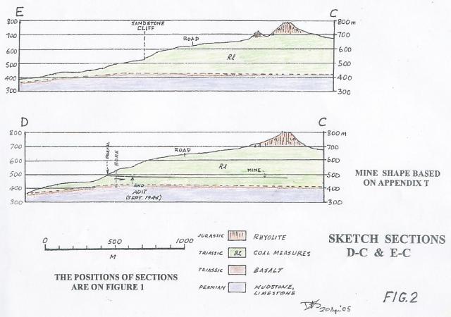
At that time, I believed that the whole of the mine workings sloped northwards (down the dip of the coal), as shown on Figure 2. When preparing this supplementary proof I discovered that to the north of the Main Adit, the mine sloped at about 3 degrees towards the south, i.e. back towards the portal (see Appendix T of Stapledon, 2005a). In light of this, I consider that the potential for further landsliding near the portal, with the possibility of associated large outflows of water, needs to be investigated carefully. Permanent drainage measures may be required.
Rallings (2005) has described in very simple terms the theory of why water levels in the ground are so important in slope stability. The only point I would like to add, in respect to rock slides, and Slide B in particular, is that his assumed specific yield of 5% is likely to be too high. In undisturbed rock masses, values of 0.1% or less are likely
Large water level rises must occur above the Slide B failure surfaces during the periods of intense rainfall recorded in the area. No obvious evidence of movement younger than the oldest trees has been found, but the graben feature suggests that some movement of at least the steep lower half of the mass was perhaps not much older than the trees. There might be other and more convincing evidence of the youngest movements, but to find it will require a careful investigation.
I am unable to quantify the risk of renewed movements should the proposed harvesting occur. I agree that an initial 200mm or 100mm of increased annual infiltration could be dwarfed by variations from the mean annual rainfall (McIntosh, 2005a, p.4). However this extra infiltration must add to water level rises due to rainfall events, and so increase the risk of renewed movements at Slide B, during or soon after peak rainfall events in the first years after thinning. It should be remembered that annual increases in infiltration will have cumulative impacts over a number of years.
In my opinion, if an extreme rainfall event (equivalent to or in excess of the largest previously recorded) occurs during these first years, then there would be real chance of renewed movements at Slide B. Using the descriptions in Appendix G of the Australian Geomechanics Society Landslide Management Concepts and Guidelines (Landslide Risk Assessment - Example of Qualitative Terminology), slope failure would be likely to occur.
The consequences of reactivation of Slide B could be relatively minor, e.g.
However, the consequences could also be more serious, and include:
In my opinion, the stability of the whole north-east facing slope of Coupe NI 114A (Zone E in Rallings (2005) cannot be properly assessed until a further investigation in accordance with the principles set out on Attachment 1 is completed successfully.
This will require an engineering or geotechnical engineer with proven ability in structural geology and landslide studies, and geotechnical mapping as described in Fell et al (1992).
In my view avoidance is usually the best way (first choice) to treat a known landslide or areas suspected to be unstable. To illustrate this I include again here, Attachment W3 from Stapledon, 2005a. I have underlined some important words. The book has now been published, however the page numbers in the published version differ from those in Attachment W3.
David Stapledon
8 September 2005
Australian Geomechanics Society Sub-Committee on Landslide Risk Management, Landslide Risk Management Concepts and Guidelines, AGS journal, Vol. 37, May 2002.
Erskine, Wayne. Proof of Evidence xx/2005
McIntosh, Peter. Proof of Evidence xx/2005 (McIntosh, 2005a)
McIntosh, Peter. Land stability on Coupe NI 114A and adjacent steeplands
Rallings, Ralph. Proof of Evidence dated 5/05/05
Stapledon, David. Proof of Evidence dated 8 May 2005 (Stapledon 2005a)
Weldon, Barry. Proof of Evidence dated 18 August 2005
6886 (1, 4, 17, 44)