South Sister St. Marys, Tasmania
GEOLOGICAL STUDIES NEAR SOUTH SISTERS, TASMANIA
David Stapledon
Investigations in the South Sister have involved examinations of air photos, contour plans and maps of MRT, followed by less than 3 days traversing the area within and around the proposed coupe. During the traversing we found:
We also examined the steep slopes above the proposed Coupe, close to South Sister. I am not convinced that large dolorite mass just below the Sister was moved there by landsliding. We did not find evidence of old landslides on these upper slopes, but it could be there. We found 2 suspect areas on the gentle slopes within the proposed Coupe area. I consider that the water level rising which would occur during the first few years after 50% thinning would increase the risk of renewed movements at the old slides. Further more detailed studies should be carried out to quantify the risk at these slides, particularly along the whole north-eastern face, and to locate other old slides - particularly on the southern escarpment.
I have not made any assessment of the consequences of renewed landsliding, but I have been to the sites of two major (overseas) landslide disasters, and seen the faces of the survivors; not pleasant but it sharpens the mind.
I have been involved in this matter since October 2004, when I agreed to provide geological advice to a group of residents in the South Sister area. The residents were concerned about the possibility of loss of water supplies, and landsliding in the slopes below South Sister, if logging (50% thinning) was carried out at the proposed Coupe NI 114A. I agreed to assess the landsliding issue only. Between October 2004 and March 2005, I reviewed a number of expert reports relating to the proposed harvesting operations (see References 1-3, 6-8) and general information, including:
I initially prepared two short letter-reports commenting on the landslide risks presented by the proposed operations (References 4 & 5).
I visited the site of Coupe NI 114A and surround on 12 - 14 April 2005, accompanied by Mr. Ralph Rallings. Appendix R shows the routes taken during this inspection.
While preparing this evidence I have made all enquiries which I believe are desirable and appropriate and declare that no matters of significance which I regard as relevant have, to my knowledge, been withheld from the Tribunal.
I started this assignment by defining the following Key Question:
Would the proposed forestry operations on Coupe NI 114A cause the emission, discharge or escape of water which would cause unacceptable risks of landsliding below, above or within it, such that the Coupe should be modified or abandoned?
Comments on the question
I have assumed that there would be no cutting into the slopes within or below the Coupe as part of the proposed forestry operations.
It seems to be accepted by both Dr. Leaman (Ref. 1) and Dr. Lane (Ref. 8, Page 9) that up to 200mm of additional water will infiltrate annually beneath the Coupe, initially. This should result in substantial rises in water levels for the first year or so, diminishing to zero in 10 years (Ref. 8, Figure 5). Such initial rises would increase the probability of sliding in slopes within and downslope from the Coupe.
Based on logic, and long personal experience at construction and mining sites, I believe that there would be a significant increase in runoff from the coupe during period of prolonged and/or intense rainfall, at least in for a few years following logging. In times of extreme rainfall, this would increase the probability of erosion, landsliding, and the formation of debris flows.
There is evidence of past landsliding in the slopes below the Coupe. During the site inspection of 12-14 April 2005, we found definite old slides A and B on the northeastern slope above Dublin Town Road. Each show some leaning trees, and the rocky ridge between them also has some leaning trees. The southern part of this slope is likely to be affected by the northern extension of the Gould Fault and its connection with the mapped fault 400m to the north (see notes on Feature 14, in Section 5). I suspect that careful studies will find that most of this northeastern slope, from the Cardiff Mine corner to the North Sister corner, has suffered some past landsliding. In my opinion, this should be investigated thoroughly before any forestry operations are considered or allowed.
With respect to the south-facing escarpment below the 600m contour, it is my opinion that careful studies here also would find evidence of past, probably shallow, sliding. I base this view on the steepness of the slopes, the fact that the beds are almost horizontal, talus-covered, and that in only one traverse down the slope we found the scarps of 2 small slides, and in only one traverse up the slope 600m away we found another larger but similar scarp. The landslipped materials from these 3 events had gone down the slope - in one case we found the channel of the debris flow initiated by the slide. This also needs to be investigated thoroughly prior to allowing any forestry operations to proceed.
I do not know whether water level rise and runoff effects from the proposed logging would definitely reactivate any of the definite or probable past landslides. However, in my opinion this is likely and should be thoroughly investigated. I have not addressed the consequences of landslide activity, but in my opinion this matter should be considered in detail before proceeding with forestry operations.
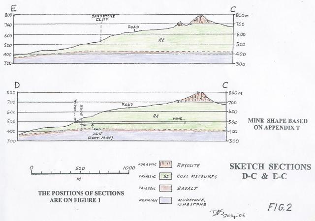
I understand that selective logging was carried out on the Coupe mainly during the late 1940s and early 1950s, when the slopes were being drained due to pumping by Jubilee Mine (See Appendix W5, Page 13). The stabilising effect of coal mine pumping at Jubilee mine would be lost now, and the mine is likely to be full of water. As explained in the discussion of Feature 14, in 3.0 below, subsidence of the ground above totally extracted areas could increase the probability of sliding. See Appendices V and W4.
It should be noted on Appendix V that there are 3 main 'total extraction' areas (shown in dark grey) labelled X, Y and Z. In these areas the pillars between the tunnels were removed. As pillars are removed, the overlying rock collapses to fill the space, and the settling down of this rock is reflected in subsidence at the ground surface above (see Appendix W, Item W4). There will have been some subsidence over each of Areas X, Y and Z. As explained in Figures 12 and 13 of Appendix W4, the amount of subsidence reaches a maximum amount, always less than the thickness of the coal seam, when the area of total extraction is a little wider than the depth below the ground surface. This criterion for maximum subsidence is not quite met at total extraction area X, which is about 150m square, and about 160m below the swampy depression at Feature 8. However, the subsidence at Feature 8 area could cause movements at the talus/bedrock interface and thus contribute to slope instability here.
The most significant part the operating Jubilee mine played in the stability of the overlying slopes, would have been the drainage of the ground it achieved by pumping. The beneficial effect of this is now lost (see Appendix W5).
DAVID STAPLEDON
8 May 2005
1. Leaman, D.E. (2003) Appraisal of initial forest plan, South Sister - Nicholas Range. Hydrological and Landscape Observations. Report dated 22 November 2003
2. Comments by P.D. McIntosh on report of D.E. Leaman's November 2003 report
3. Comments on P.D. McIntosh criticisms, by D.E. Leaman
4. Stapledon, David (2004) Initial Forest Plan, South Sister Nicholas Range, Comments on reports by D.E.Leaman and P.D. McIntosh. Dated 6 October, 2004
5. Stapledon, David (2005) Letter to Frances Daily, dated 30 Jan. 2005
6. Letter dated 5 February 2005 from Chief Forest Practices Officer to Dr Frances Daily, with comments by Peter McIntosh, on various reports
7. Letter dated 7 March 2005 from Ralph Rallings to Hon B Green, Minister for Infrastructure, Environment and Resources
8. Lane, P. (2005) Scientific Review of Water supply impacts of Proposed Forestry Operations in State Forest Coupes NI 114A at South Sister, North of St Marys
9. Fell, R., MacGregor, P and Stapledon, D. (1992). Geotechnical Engineering of Embankment Dams. Balkema, 675pp.
P - St Mary's Geological Sheet
Q - Landslide areas in St Marys area
R - Where we went
S - Common indicators of past slope stability
T - Jubilee Mine, Sketch Cross Section
U - David Stapledon, CV, list of publications, and summary of experience with landslides
V - Plan showing layouts of workings, Jubilee and Cardiff Mines
W - Supporting Evidence
SUMMARY OF QUALIFICATIONS AND EXPERIENCE
Education Qualifications:
Board/Panel Memberships:
Awards:
Professional Experience:
| 1994 to date | Geotechnical Consultant |
| 1993 | Engineering Geology Consultant, Golder Associates,
and part-time Professor of Applied Geology, University of South
Australia |
| 1987 - 1992 | Geotechnical Consultant, and part-time
Professor of Applied Geology, University of South Australia |
| 1977 - 1986 | South Australian Institute of Technology,
Professor of Applied Geology (1978), Head of Applied
Geology (1977) Teaching (at undergraduate and graduate levels) the applications of geology in civil and mining engineering; School management; geotechnical consulting |
| 1970 - 1977 | Coffey and Partners, Consulting Engineers in the
Geotechnical Sciences. Director (1974), Responsible for direction of geotechnical investigations for major civil engineering and mining projects. Associate Director (1971), Founder of Adelaide Office (1970) |
| 1964 - 1970 | Department of Mines, South Australia. Director of Division including Engineering Geology and Hydrogeology Sections. Responsible for engineering geological and hydrogeological studies for major and minor civil engineering projects, mostly associated with water supply. Supervising Geologist, Engineering Division (1965) Senior Geologist, Engineering Geology Section (1964) |
| 1951 - 1963 | Snowy Mountains Hydro- Electricity Authority. Supervising Scientific Officer (1962) Regional Engineering Geologist, Lower Tumut Region, and member of the Authority's Mekong River Project team, working in Cambodia, Thailand and Laos Senior Scientific Officer (1957) Regional Engineering Geologist, in charge of geological work during construction, Upper Tumut works. Geologist Grade 1 (1951) Routine engineering geological investigations during the planning of hydroelectric works. |
| 1951 | APAC Industries Ltd, Adelaide Clerical Officer, clerical duties in Production Control Department |
Publications: 16 papers and 1 textbook, in the geotechnical field
Experience:
Professional Society Memberships:
Stapledon, D.H, 1967: Geological Investigations at the Site for Kangaroo Creek Dam, South Australia, Trans IE Aust, Vol CE9, No 1, pp 31-43
Stapledon, D.H, 1971: Changes and Structural Defects Developed in some South Australian Clays, and their Engineering Consequences. Proc. Symp. On Soils and Earth Structures in Arid Climates, Adelaide, 1970, IE Aust. Also published in Golden Jubilee of the International Society for Soil Mechanics and Foundation Engineering, Commemorative Volume, IE Aust, 1985, pp145-154
Stapledon, D.H, 1976: Geological Hazards and Water Storage. A paper presented to the International Geological Congress, Sydney, 1976. Bull IAEG, No. 14
Stapledon, D.H and Casinader, R.J, 1977: Dispersive Soils at Sugarloaf Dam Site, near Melbourne, Australia. Dispersive Clays, Related Piping, and erosion in Geotechnical Projects, ASTM. STP 623, JL Sherard and RS Decker, Eds, American Society for Testing and Materials
Stapledon, D.H, Woodburn, JA and Fitzhardinge, CFR, 1977: Planning construction and operation of Kanmantoo Mine Tailings Dam. Australian National Committee on Large Dame, Bulletin No. 49
Casinader, R.J. and Stapledon, D.H., 1979: The effect of geology on the treatment of the dam foundation interface of Sugarloaf Dam. International Commission on Large Dames, 13th Congress, New Delhi.
Stapledon, D.H, 1979: Investigation and Characterisation. Extension Course on Tunnelling Design and Practise, Aus Geomechanics Society, sponsored by the Institution of Engineers, Australia and the Australasian Institute of Mining and Metallurgy, Melbourne.
Stapledon, D.H, 1982: Subsurface Engineering - In Search of a Rational Approach. Australian Geomechanics News, June 1982
Stapledon, D.H, and Rissler, P., 1983: Site Exploration and Evaluation, General Report on Theme A. Proc 5th Int. Congress on Rock Mechanics, Melbourne
Stapledon, D.H, 1983: The Geotechnical Specialist and Contractual Disputes. Invited Pater, in collected Case studies in Engineering Geology, Hydrology and Environmental Geology. Geological Society of Australia, Sydney.
Stapledon, D.H, 1983: Towards Successful Waterworks. Keynote Pater. Proc of the Symposium on Engineering for Dams and Canals, Alexandra, Inst. Prof. Eng NZ
Stapledon, D.H, 1986: Let's keep the 'geo' in Geomechanics. Keynote paper. Proc. Speciality Symposium of Insitu Testing, Adelaide, Aus. Geomechanics Society
Stapledon, D.H, 1988: Engineering Geophysics: a geologist's view. Aust. Geomechanics, 15, pp 57-62
Stapledon, D.H, 1988: Engineering description of weathered rock - a standard system? Australian National Committee on Large Dams, Bulletin 81, pp 35-48
Stapledon, D.H, 1995: Geological Modelling in landslide investigation. Invited paper on Theme 1, 6th International Symposium on Landslides, Christchurch
Fell, R., MacGregor, J.P. and Stapledon, D.H. 1992: Geotechnical engineering of embankment of dams. Balkema pp669
Stapledon, D.H, 1996: Keeping the 'geo'; Why and How. Fourth Jaeger Memorial Lecture. Proc. 7th ANZ Conference on Geomechanics, Adelaide. The Institution of Engineers, Australia, pp3 to 18.
My landslide experiences began with unforgettable terror; a narrow escape from death under one of three debris flows initiated by landslides just below recently cleared slopes. The slides occurred during a thunderstorm in which 110mm of rain fell in 70 minutes. This was in the Snowy Mountains, NSW, in 1955. Since that time I have contributed to the investigation of, and in many cases to decision on the treatment of more than 50 landslides, in Australia, New Zealand, Papua New Guinea and Indonesia. The slides have ranged from small (affecting roads, housing areas and pipelines) to large (affecting open pit mines, dams and reservoirs).
The following key (and most stressful) landslide projects are referred to in Stapledon (1995)
During 1997-1998 I took part in investigations at the site of the Thredbo landslide, and reported on evidence indicating that water entry beneath the retaining wall was the most likely factor contributing to the slide. When the wall was demolished it became clear to me that it could not have been the main factor. I admitted this and endorsed the evidence of Mr Tim Sullivan, the geotechnical expert assisting the Coroner.
My most recent landslide-related work was in November 2004, back where it all started, in the Snowy Mountains.
13618 (1, 7, 16, 247)